Cerlongo geodata
Cerlongo (Lombardy) is a populated place; located in Italy in Europe/Rome (GMT+2) time zone. With population of 1,418 people, there are 5318 cities with bigger population in this country. Compared to other cities in Italy, 66.9% of cities are located further ↓South; 61.4% of cities are located further →East and 81.7% of cities have higher elevation than Cerlongo. Note1


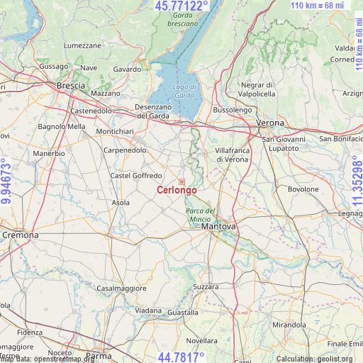
Cerlongo GPS coordinates[2]
45° 16' 43.032" North, 10° 38' 59.46" East
| Map corner | latitude | longitude |
|---|---|---|
| Upper-left | 45.77122°, | 9.94673° |
| Center: | 45.27862°, | 10.64985° |
| Lower-right: | 44.7817°, | 11.35298° |
| Map W x H: | 110×110 km | = 68.4×68.4mi |
| max Lat: | 47.04031° ⇑33.1% North |
| Cerlongo: | 45.27862° |
| min Lat: | ⇓66.9% South 35.50142° |
| min Long | Cerlongo | max Long |
| 6.69888° | 10.64985° | 18.48682° |
| W 38.6%⇐ | ⇒61.4% E |
Elevation
Elevation of Cerlongo is 43 m = 141 ft, and this is 263.7 m = 865 ft below average elevation for this country.
| Max E: |
2085 m = 6841 ft | 81.7% |
| Avg. | 306.7 m = 1006 ft | |
| Cerlongo | 43 m = 141 ft | |
Min E: |
-4 m = -13 ft | 18.3% |
See also: Italy elevation on elevation.city.
Geographical zone
Cerlongo is located in North temperate zone (between Tropic of Cancer and the Arctic Circle). Distance of this North polar circle is 2366.7 km =1470.6 mi to North.| Distance of | km | miles | from Cerlongo |
|---|---|---|---|
| North Pole | 4972.6 | 3089.8 | to North |
| Arctic Circle | 2366.7 | 1470.6 | to North |
| Tropic Cancer | 2428.6 | 1509.1 | to South |
| Equator | 5034.5 | 3128.3 | to South |


Nearby cities:
15 places around Cerlongo: (largest is in red/bold)
• Cavriana
8.8 km =5.5 mi,  331°
331°
• Ceresara
6.5 km =4 mi,  253°
253°
• Cereta
3 km =1.9 mi,  347°
347°
• Gazoldo degli Ippoliti
10.4 km =6.5 mi,  212°
212°
• Goito
3.2 km =2 mi,  163°
163°
• Guidizzolo
7.3 km =4.5 mi,  309°
309°
• Marmirolo
10.6 km =6.6 mi,  128°
128°
• Piubega
10.9 km =6.8 mi,  238°
238°
• Pozzolo
5.9 km =3.7 mi,  63°
63°
• Rodigo
9 km =5.6 mi,  192°
192°
• Roverbella
9.5 km =5.9 mi,  98°
98°
• Soave
10.9 km =6.8 mi,  148°
148°
• Valeggio sul Mincio
10.7 km =6.6 mi,  39°
39°
• Volta Mantovana
4.9 km =3 mi,  8°
8°
• Zona Artigianale Foroni
9.5 km =5.9 mi, 44°
Sources, notices
• [Note1] Compared only with cities in Italy existing in our database
• [Src1] Map data: © OpenStreetMap contributors (CC-BY-SA)
• [Src2] Other city data from geonames.org with taken over terms of usage.
• [Src3] Geographical zone / Annual Mean Temperature by Robert A. Rohde @ Wikipedia
