Balzo geodata
Balzo (The Marches) is a seat of a third-order administrative division; located in Italy in Europe/Rome (GMT+2) time zone. With population of 123 people, there are 11371 cities with bigger population in this country. Compared to other cities in Italy, 64.4% of cities are located further ↑North; 71.7% of cities are located further ←West and 94.9% of cities have lower elevation than Balzo. Note1
Administrative division(s):
- Level 1: The Marches
- Level 2: Provincia di Ascoli Piceno
- Level 3: Montegallo


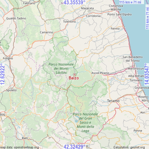
Balzo GPS coordinates[2]
42° 50' 31.164" North, 13° 19' 56.424" East
| Map corner | latitude | longitude |
|---|---|---|
| Upper-left | 43.35539°, | 12.62922° |
| Center: | 42.84199°, | 13.33234° |
| Lower-right: | 42.32429°, | 14.03547° |
| Map W x H: | 114.6×114.6 km | = 71.2×71.2mi |
| max Lat: | 47.04031° ⇑64.4% North |
| Balzo: | 42.84199° |
| min Lat: | ⇓35.6% South 35.50142° |
| min Long | Balzo | max Long |
| 6.69888° | 13.33234° | 18.48682° |
| W 71.7%⇐ | ⇒28.3% E |
Elevation
Elevation of Balzo is 872 m = 2861 ft, and this is 565.3 m = 1855 ft above average elevation for this country.
| Max E: |
2085 m = 6841 ft | 5.1% |
| Balzo | 872 m 2861 ft | |
| Avg. | 306.7 m = 1006 ft | |
Min E: |
-4 m = -13 ft | 94.9% |
See also: Italy elevation on elevation.city.
Geographical zone
Balzo is located in North temperate zone (between Tropic of Cancer and the Arctic Circle). Distance of this Northern Tropic circle is 2157.7 km =1340.7 mi to South.| Distance of | km | miles | from Balzo |
|---|---|---|---|
| North Pole | 5243.5 | 3258.2 | to North |
| Arctic Circle | 2637.6 | 1638.9 | to North |
| Tropic Cancer | 2157.7 | 1340.7 | to South |
| Equator | 4763.6 | 2960 | to South |


Nearby cities:
15 places around Balzo: (largest is in red/bold)
• Accumoli
17.8 km =11.1 mi,  202°
202°
• Acquasanta Terme
10.4 km =6.5 mi,  139°
139°
• Amandola
15.3 km =9.5 mi,  6°
6°
• Arquata del Tronto
8.4 km =5.2 mi, 201°
• Castelsantangelo sul Nera
15.6 km =9.7 mi,  291°
291°
• Comunanza
14.4 km =8.9 mi,  27°
27°
• Marsia
11.9 km =7.4 mi,  80°
80°
• Montefortino
11.3 km =7 mi,  4°
4°
• Montemonaco
6.3 km =3.9 mi,  358°
358°
• Mozzano
14.7 km =9.1 mi,  95°
95°
• Paggese-Santa Maria
10 km =6.2 mi, 135°
• Palmiano
12.2 km =7.6 mi,  58°
58°
• Valle Castellana
17.9 km =11.1 mi,  131°
131°
• Venagrande
18 km =11.2 mi,  72°
72°
• Venarotta
13.7 km =8.5 mi, 70°
Sources, notices
• [Note1] Compared only with cities in Italy existing in our database
• [Src1] Map data: © OpenStreetMap contributors (CC-BY-SA)
• [Src2] Other city data from geonames.org with taken over terms of usage.
• [Src3] Geographical zone / Annual Mean Temperature by Robert A. Rohde @ Wikipedia
