Valle e Castello geodata
Valle e Castello (The Marches) is a seat of a third-order administrative division; located in Italy in Europe/Rome (GMT+2) time zone. With population of 66 people, there are 11548 cities with bigger population in this country. Compared to other cities in Italy, 63.1% of cities are located further ↑North; 69.3% of cities are located further ←West and 80.5% of cities have lower elevation than Valle e Castello. Note1


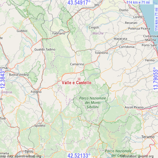
Valle e Castello GPS coordinates[2]
43° 2' 14.64" North, 13° 5' 14.712" East
| Map corner | latitude | longitude |
|---|---|---|
| Upper-left | 43.54917°, | 12.3843° |
| Center: | 43.0374°, | 13.08742° |
| Lower-right: | 42.52133°, | 13.79055° |
| Map W x H: | 114.3×114.3 km | = 71×71mi |
| max Lat: | 47.04031° ⇑63.1% North |
| Valle e Castello: | 43.0374° |
| min Lat: | ⇓36.9% South 35.50142° |
| min Long | Valle e Castell | max Long |
| 6.69888° | 13.08742° | 18.48682° |
| W 69.3%⇐ | ⇒30.7% E |
Elevation
Elevation of Valle e Castello is 531 m = 1742 ft, and this is 224.3 m = 736 ft above average elevation for this country.
| Max E: |
2085 m = 6841 ft | 19.5% |
| Valle e Castello | 531 m 1742 ft | |
| Avg. | 306.7 m = 1006 ft | |
Min E: |
-4 m = -13 ft | 80.5% |
See also: Italy elevation on elevation.city.
Geographical zone
Valle e Castello is located in North temperate zone (between Tropic of Cancer and the Arctic Circle). Distance of this Northern Tropic circle is 2179.4 km =1354.2 mi to South.| Distance of | km | miles | from Valle e Castello |
|---|---|---|---|
| North Pole | 5221.8 | 3244.7 | to North |
| Arctic Circle | 2615.9 | 1625.4 | to North |
| Tropic Cancer | 2179.4 | 1354.2 | to South |
| Equator | 4785.3 | 2973.4 | to South |


Nearby cities:
15 places around Valle e Castello: (largest is in red/bold)
• Bolognola
12.4 km =7.7 mi,  113°
113°
• Caldarola
16.1 km =10 mi,  43°
43°
• Camerino
11.4 km =7.1 mi,  351°
351°
• Castelsantangelo sul Nera
16.9 km =10.5 mi,  161°
161°
• Cessapalombo
15.9 km =9.9 mi,  60°
60°
• Fluminata
11.1 km =6.9 mi, 159°
• Muccia
6.2 km =3.9 mi,  324°
324°
• Pie' del Colle
7.2 km =4.5 mi,  96°
96°
• Pie' del Sasso
8.6 km =5.3 mi,  236°
236°
• Pieve Torina
3.3 km =2.1 mi,  280°
280°
• Pievebovigliana
2.8 km =1.7 mi, 353°
• Sefro
16.6 km =10.3 mi, 317°
• Serravalle di Chienti
11.6 km =7.2 mi,  289°
289°
• Trebbio
5.4 km =3.4 mi,  90°
90°
• Visso
11.6 km =7.2 mi,  182°
182°
Sources, notices
• [Note1] Compared only with cities in Italy existing in our database
• [Src1] Map data: © OpenStreetMap contributors (CC-BY-SA)
• [Src2] Other city data from geonames.org with taken over terms of usage.
• [Src3] Geographical zone / Annual Mean Temperature by Robert A. Rohde @ Wikipedia
