Stienta geodata
Stienta (Veneto) is a seat of a third-order administrative division; located in Italy in Europe/Rome (GMT+2) time zone. With population of 1,947 people, there are 4253 cities with bigger population in this country. Compared to other cities in Italy, 58.6% of cities are located further ↓South; 50% of cities are located further ←West and 94.8% of cities have higher elevation than Stienta. Note1


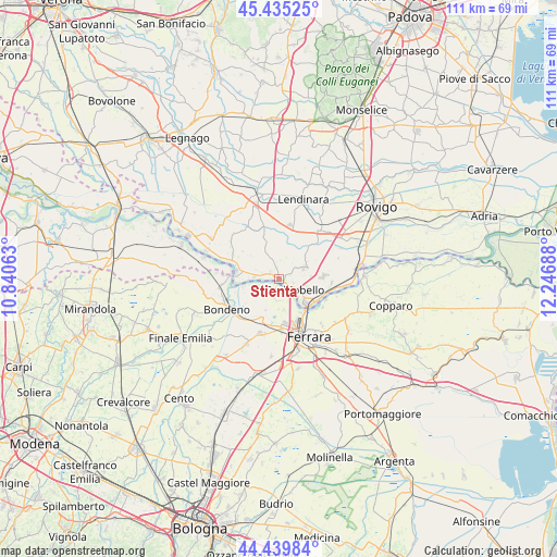
Stienta GPS coordinates[2]
44° 56' 22.92" North, 11° 32' 37.5" East
| Map corner | latitude | longitude |
|---|---|---|
| Upper-left | 45.43525°, | 10.84063° |
| Center: | 44.9397°, | 11.54375° |
| Lower-right: | 44.43984°, | 12.24688° |
| Map W x H: | 110.7×110.7 km | = 68.8×68.8mi |
| max Lat: | 47.04031° ⇑41.4% North |
| Stienta: | 44.9397° |
| min Lat: | ⇓58.6% South 35.50142° |
| min Long | Stienta | max Long |
| 6.69888° | 11.54375° | 18.48682° |
| W 50%⇐ | ⇒50% E |
Elevation
Elevation of Stienta is 9 m = 30 ft, and this is 297.7 m = 977 ft below average elevation for this country.
| Max E: |
2085 m = 6841 ft | 94.8% |
| Avg. | 306.7 m = 1006 ft | |
| Stienta | 9 m = 30 ft | |
Min E: |
-4 m = -13 ft | 5.2% |
See also: Italy elevation on elevation.city.
Geographical zone
Stienta is located in North temperate zone (between Tropic of Cancer and the Arctic Circle). Distance of this Northern Tropic circle is 2390.9 km =1485.6 mi to South.| Distance of | km | miles | from Stienta |
|---|---|---|---|
| North Pole | 5010.2 | 3113.2 | to North |
| Arctic Circle | 2404.3 | 1494 | to North |
| Tropic Cancer | 2390.9 | 1485.6 | to South |
| Equator | 4996.8 | 3104.9 | to South |


Nearby cities:
15 places around Stienta: (largest is in red/bold)
• Bagnolo di Po
9.1 km =5.7 mi,  338°
338°
• Canaro
10.4 km =6.5 mi,  93°
93°
• Casaglia
4.2 km =2.6 mi,  181°
181°
• Castelguglielmo
9.5 km =5.9 mi,  356°
356°
• Ficarolo
8.6 km =5.3 mi,  280°
280°
• Fiesso Umbertiano
5.4 km =3.4 mi,  64°
64°
• Francolino
10.1 km =6.3 mi,  118°
118°
• Gaiba
5 km =3.1 mi, 277°
• Occhiobello
3.5 km =2.2 mi, 122°
• Pincara
9.1 km =5.7 mi,  41°
41°
• Porotto-Cassama
10 km =6.2 mi, 177°
• Sabbioni-Zampine
2.2 km =1.4 mi,  308°
308°
• Salara
10.6 km =6.6 mi,  299°
299°
• Santa Maria Maddalena
6.5 km =4 mi,  130°
130°
• Vigarano Pieve
9.1 km =5.7 mi,  197°
197°
Sources, notices
• [Note1] Compared only with cities in Italy existing in our database
• [Src1] Map data: © OpenStreetMap contributors (CC-BY-SA)
• [Src2] Other city data from geonames.org with taken over terms of usage.
• [Src3] Geographical zone / Annual Mean Temperature by Robert A. Rohde @ Wikipedia
