Mantignano-Ugnano geodata
Mantignano-Ugnano (Tuscany) is a populated place; located in Italy in Europe/Rome (GMT+2) time zone. With population of 2,893 people, there are 3125 cities with bigger population in this country. Compared to other cities in Italy, 57.2% of cities are located further ↑North; 54.8% of cities are located further →East and 82.9% of cities have higher elevation than Mantignano-Ugnano. Note1


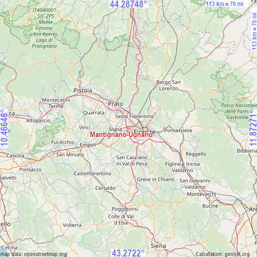
Mantignano-Ugnano GPS coordinates[2]
43° 46' 55.2" North, 11° 10' 10.488" East
| Map corner | latitude | longitude |
|---|---|---|
| Upper-left | 44.28748°, | 10.46646° |
| Center: | 43.782°, | 11.16958° |
| Lower-right: | 43.2722°, | 11.87271° |
| Map W x H: | 112.9×112.9 km | = 70.2×70.2mi |
| max Lat: | 47.04031° ⇑57.2% North |
| Mantignano-Ugnano: | 43.782° |
| min Lat: | ⇓42.8% South 35.50142° |
| min Long | Mantignano-Ugna | max Long |
| 6.69888° | 11.16958° | 18.48682° |
| W 45.2%⇐ | ⇒54.8% E |
Elevation
Elevation of Mantignano-Ugnano is 38 m = 125 ft, and this is 268.7 m = 882 ft below average elevation for this country.
| Max E: |
2085 m = 6841 ft | 82.9% |
| Avg. | 306.7 m = 1006 ft | |
| Mantignano-Ugnano | 38 m = 125 ft | |
Min E: |
-4 m = -13 ft | 17.1% |
See also: Italy elevation on elevation.city.
Geographical zone
Mantignano-Ugnano is located in North temperate zone (between Tropic of Cancer and the Arctic Circle). Distance of this Northern Tropic circle is 2262.2 km =1405.7 mi to South.| Distance of | km | miles | from Mantignano-Ugnano |
|---|---|---|---|
| North Pole | 5139 | 3193.2 | to North |
| Arctic Circle | 2533.1 | 1574 | to North |
| Tropic Cancer | 2262.2 | 1405.7 | to South |
| Equator | 4868.1 | 3024.9 | to South |


Nearby cities:
15 places around Mantignano-Ugnano: (largest is in red/bold)
• Calenzano
8.1 km =5 mi,  358°
358°
• Campi Bisenzio
5.7 km =3.5 mi,  326°
326°
• Chiesanuova
8.7 km =5.4 mi,  171°
171°
• Florence
6.2 km =3.9 mi,  92°
92°
• Il Rosi
8.7 km =5.4 mi,  344°
344°
• Lastra a Signa
4.8 km =3 mi,  253°
253°
• Malmantile
8.7 km =5.4 mi,  243°
243°
• Quattro Strade
8.4 km =5.2 mi, 237°
• San Donnino
2.4 km =1.5 mi,  309°
309°
• San Martino alla Palma
4.2 km =2.6 mi,  209°
209°
• San Mauro
3.8 km =2.4 mi,  290°
290°
• Scandicci
3.4 km =2.1 mi,  154°
154°
• Sesto Fiorentino
6 km =3.7 mi,  23°
23°
• Signa
5.5 km =3.4 mi,  284°
284°
• Tavarnuzze
8.9 km =5.5 mi, 154°
Sources, notices
• [Note1] Compared only with cities in Italy existing in our database
• [Src1] Map data: © OpenStreetMap contributors (CC-BY-SA)
• [Src2] Other city data from geonames.org with taken over terms of usage.
• [Src3] Geographical zone / Annual Mean Temperature by Robert A. Rohde @ Wikipedia
