Montefalco geodata
Montefalco (Umbria) is a seat of a third-order administrative division; located in Italy in Europe/Rome (GMT+2) time zone. With population of 1,290 people, there are 5664 cities with bigger population in this country. Compared to other cities in Italy, 64% of cities are located further ↑North; 64.3% of cities are located further ←West and 73.3% of cities have lower elevation than Montefalco. Note1


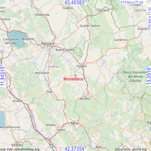
Montefalco GPS coordinates[2]
42° 53' 27.024" North, 12° 38' 53.772" East
| Map corner | latitude | longitude |
|---|---|---|
| Upper-left | 43.40383°, | 11.94515° |
| Center: | 42.89084°, | 12.64827° |
| Lower-right: | 42.37354°, | 13.3514° |
| Map W x H: | 114.6×114.6 km | = 71.2×71.2mi |
| max Lat: | 47.04031° ⇑64% North |
| Montefalco: | 42.89084° |
| min Lat: | ⇓36% South 35.50142° |
| min Long | Montefalco | max Long |
| 6.69888° | 12.64827° | 18.48682° |
| W 64.3%⇐ | ⇒35.7% E |
Elevation
Elevation of Montefalco is 428 m = 1404 ft, and this is 121.3 m = 398 ft above average elevation for this country.
| Max E: |
2085 m = 6841 ft | 26.7% |
| Montefalco | 428 m 1404 ft | |
| Avg. | 306.7 m = 1006 ft | |
Min E: |
-4 m = -13 ft | 73.3% |
See also: Italy elevation on elevation.city.
Geographical zone
Montefalco is located in North temperate zone (between Tropic of Cancer and the Arctic Circle). Distance of this Northern Tropic circle is 2163.1 km =1344.1 mi to South.| Distance of | km | miles | from Montefalco |
|---|---|---|---|
| North Pole | 5238 | 3254.7 | to North |
| Arctic Circle | 2632.2 | 1635.6 | to North |
| Tropic Cancer | 2163.1 | 1344.1 | to South |
| Equator | 4769 | 2963.3 | to South |


Nearby cities:
15 places around Montefalco: (largest is in red/bold)
• Bastardo
7.6 km =4.7 mi,  253°
253°
• Bevagna
5.9 km =3.7 mi,  332°
332°
• Bruna
8.5 km =5.3 mi,  157°
157°
• Cannaiola
6.1 km =3.8 mi,  118°
118°
• Castel Ritaldi
7.9 km =4.9 mi, 164°
• Corciano-Pigge
9.5 km =5.9 mi, 118°
• Fiamenga
7.1 km =4.4 mi,  8°
8°
• Foligno
8.4 km =5.2 mi,  31°
31°
• Giano dell'Umbria
8.6 km =5.3 mi,  222°
222°
• Gualdo Cattaneo
7.8 km =4.8 mi,  287°
287°
• Maceratola
6.8 km =4.2 mi,  15°
15°
• Marcellano
10.9 km =6.8 mi,  260°
260°
• Santa Maria in Valle
8.3 km =5.2 mi,  88°
88°
• Spello
11.4 km =7.1 mi, 7°
• Trevi
8.4 km =5.2 mi,  100°
100°
Sources, notices
• [Note1] Compared only with cities in Italy existing in our database
• [Src1] Map data: © OpenStreetMap contributors (CC-BY-SA)
• [Src2] Other city data from geonames.org with taken over terms of usage.
• [Src3] Geographical zone / Annual Mean Temperature by Robert A. Rohde @ Wikipedia
