Codroipo geodata
Codroipo (Friuli Venezia Giulia) is a seat of a third-order administrative division; located in Italy in Europe/Rome (GMT+2) time zone. With population of 12,811 people, there are 719 cities with bigger population in this country. Compared to other cities in Italy, 91% of cities are located further ↓South; 68.1% of cities are located further ←West and 82% of cities have higher elevation than Codroipo. Note1
Administrative division(s):
- Level 1: Friuli Venezia Giulia
- Level 2: Provincia di Udine
- Level 3: Codroipo


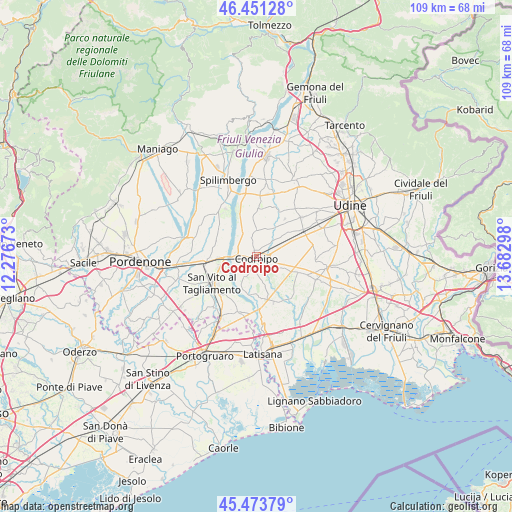
Codroipo GPS coordinates[2]
45° 57' 52.884" North, 12° 58' 47.46" East
| Map corner | latitude | longitude |
|---|---|---|
| Upper-left | 46.45128°, | 12.27673° |
| Center: | 45.96469°, | 12.97985° |
| Lower-right: | 45.47379°, | 13.68298° |
| Map W x H: | 108.7×108.7 km | = 67.5×67.5mi |
| max Lat: | 47.04031° ⇑9% North |
| Codroipo: | 45.96469° |
| min Lat: | ⇓91% South 35.50142° |
| min Long | Codroipo | max Long |
| 6.69888° | 12.97985° | 18.48682° |
| W 68.1%⇐ | ⇒31.9% E |
Elevation
Elevation of Codroipo is 42 m = 138 ft, and this is 264.7 m = 868 ft below average elevation for this country.
| Max E: |
2085 m = 6841 ft | 82% |
| Avg. | 306.7 m = 1006 ft | |
| Codroipo | 42 m = 138 ft | |
Min E: |
-4 m = -13 ft | 18% |
See also: Italy elevation on elevation.city.
Geographical zone
Codroipo is located in North temperate zone (between Tropic of Cancer and the Arctic Circle). Distance of this North polar circle is 2290.4 km =1423.2 mi to North.| Distance of | km | miles | from Codroipo |
|---|---|---|---|
| North Pole | 4896.3 | 3042.4 | to North |
| Arctic Circle | 2290.4 | 1423.2 | to North |
| Tropic Cancer | 2504.9 | 1556.5 | to South |
| Equator | 5110.8 | 3175.7 | to South |


Nearby cities:
15 places around Codroipo: (largest is in red/bold)
• Basiliano
8.9 km =5.5 mi,  51°
51°
• Bertiolo
6.3 km =3.9 mi,  110°
110°
• Biauzzo
4.1 km =2.5 mi,  251°
251°
• Camino al Tagliamento
4.9 km =3 mi,  213°
213°
• Gradisca
4.3 km =2.7 mi,  342°
342°
• Nespoledo-Villacaccia
8.8 km =5.5 mi,  76°
76°
• Pantianicco
7.8 km =4.8 mi,  33°
33°
• Pozzecco
8.6 km =5.3 mi,  94°
94°
• Rivolto-Lonca
4 km =2.5 mi,  121°
121°
• Romans
7.9 km =4.9 mi,  157°
157°
• Rosa
9.2 km =5.7 mi, 245°
• San Lorenzo
4.1 km =2.5 mi,  19°
19°
• Sedegliano
5.5 km =3.4 mi,  357°
357°
• Varmo
8.8 km =5.5 mi,  174°
174°
• Villaorba
8.6 km =5.3 mi, 53°
Sources, notices
• [Note1] Compared only with cities in Italy existing in our database
• [Src1] Map data: © OpenStreetMap contributors (CC-BY-SA)
• [Src2] Other city data from geonames.org with taken over terms of usage.
• [Src3] Geographical zone / Annual Mean Temperature by Robert A. Rohde @ Wikipedia
