Berra geodata
Berra (Emilia-Romagna) is a seat of a third-order administrative division; located in Italy in Europe/Rome (GMT+2) time zone. With population of 1,812 people, there are 4470 cities with bigger population in this country. Compared to other cities in Italy, 59.4% of cities are located further ↓South; 55.6% of cities are located further ←West and 99.4% of cities have higher elevation than Berra. Note1
Administrative division(s):
- Level 1: Emilia-Romagna
- Level 2: Provincia di Ferrara
- Level 3: Riva del Po


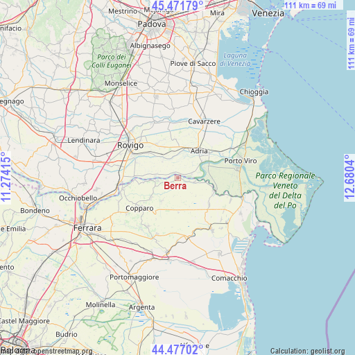
Berra GPS coordinates[2]
44° 58' 35.616" North, 11° 58' 38.172" East
| Map corner | latitude | longitude |
|---|---|---|
| Upper-left | 45.47179°, | 11.27415° |
| Center: | 44.97656°, | 11.97727° |
| Lower-right: | 44.47702°, | 12.6804° |
| Map W x H: | 110.6×110.6 km | = 68.7×68.7mi |
| max Lat: | 47.04031° ⇑40.6% North |
| Berra: | 44.97656° |
| min Lat: | ⇓59.4% South 35.50142° |
| min Long | Berra | max Long |
| 6.69888° | 11.97727° | 18.48682° |
| W 55.6%⇐ | ⇒44.4% E |
Elevation
Elevation of Berra is 1 m = 3 ft, and this is 305.7 m = 1003 ft below average elevation for this country.
| Max E: |
2085 m = 6841 ft | 99.4% |
| Avg. | 306.7 m = 1006 ft | |
| Berra | 1 m = 3 ft | |
Min E: |
-4 m = -13 ft | 0.6% |
See also: Italy elevation on elevation.city.
Geographical zone
Berra is located in North temperate zone (between Tropic of Cancer and the Arctic Circle). Distance of this Northern Tropic circle is 2395 km =1488.2 mi to South.| Distance of | km | miles | from Berra |
|---|---|---|---|
| North Pole | 5006.1 | 3110.6 | to North |
| Arctic Circle | 2400.2 | 1491.4 | to North |
| Tropic Cancer | 2395 | 1488.2 | to South |
| Equator | 5000.9 | 3107.4 | to South |


Nearby cities:
15 places around Berra: (largest is in red/bold)
• Adria
10.6 km =6.6 mi,  35°
35°
• Ambrogio
8.9 km =5.5 mi,  215°
215°
• Baricetta
9.2 km =5.7 mi,  10°
10°
• Bottrighe
9.9 km =6.2 mi,  56°
56°
• Braglia
4.5 km =2.8 mi,  78°
78°
• Cologna
6.5 km =4 mi,  262°
262°
• Corbola
9 km =5.6 mi,  71°
71°
• Crespino
7 km =4.3 mi,  277°
277°
• Gavello
7.3 km =4.5 mi,  316°
316°
• Jolanda di Savoia
10.4 km =6.5 mi,  179°
179°
• Lama Pezzoli
9.2 km =5.7 mi, 324°
• Papozze
4.3 km =2.7 mi, 76°
• Serravalle
5.6 km =3.5 mi,  102°
102°
• Valliera
9.9 km =6.2 mi,  17°
17°
• Villanova Marchesana
1.9 km =1.2 mi,  334°
334°
Sources, notices
• [Note1] Compared only with cities in Italy existing in our database
• [Src1] Map data: © OpenStreetMap contributors (CC-BY-SA)
• [Src2] Other city data from geonames.org with taken over terms of usage.
• [Src3] Geographical zone / Annual Mean Temperature by Robert A. Rohde @ Wikipedia
