Baricetta geodata
Baricetta (Veneto) is a populated place; located in Italy in Europe/Rome (GMT+2) time zone. With population of 616 people, there are 8872 cities with bigger population in this country. Compared to other cities in Italy, 61.4% of cities are located further ↓South; 55.8% of cities are located further ←West and 99.4% of cities have higher elevation than Baricetta. Note1


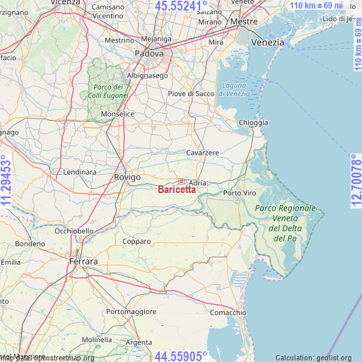
Baricetta GPS coordinates[2]
45° 3' 28.404" North, 11° 59' 51.54" East
| Map corner | latitude | longitude |
|---|---|---|
| Upper-left | 45.55241°, | 11.29453° |
| Center: | 45.05789°, | 11.99765° |
| Lower-right: | 44.55905°, | 12.70078° |
| Map W x H: | 110.5×110.5 km | = 68.7×68.7mi |
| max Lat: | 47.04031° ⇑38.6% North |
| Baricetta: | 45.05789° |
| min Lat: | ⇓61.4% South 35.50142° |
| min Long | Baricetta | max Long |
| 6.69888° | 11.99765° | 18.48682° |
| W 55.8%⇐ | ⇒44.2% E |
Elevation
Elevation of Baricetta is 1 m = 3 ft, and this is 305.7 m = 1003 ft below average elevation for this country.
| Max E: |
2085 m = 6841 ft | 99.4% |
| Avg. | 306.7 m = 1006 ft | |
| Baricetta | 1 m = 3 ft | |
Min E: |
-4 m = -13 ft | 0.6% |
See also: Italy elevation on elevation.city.
Geographical zone
Baricetta is located in North temperate zone (between Tropic of Cancer and the Arctic Circle). Distance of this North polar circle is 2391.2 km =1485.8 mi to North.| Distance of | km | miles | from Baricetta |
|---|---|---|---|
| North Pole | 4997.1 | 3105.1 | to North |
| Arctic Circle | 2391.2 | 1485.8 | to North |
| Tropic Cancer | 2404 | 1493.8 | to South |
| Equator | 5010 | 3113.1 | to South |


Nearby cities:
15 places around Baricetta: (largest is in red/bold)
• Adria
4.6 km =2.9 mi,  94°
94°
• Berra
9.2 km =5.7 mi,  190°
190°
• Beverare
9.3 km =5.8 mi,  333°
333°
• Bottrighe
7.6 km =4.7 mi,  118°
118°
• Braglia
8.6 km =5.3 mi,  160°
160°
• Ceregnano
10.2 km =6.3 mi,  263°
263°
• Corbola
9.2 km =5.7 mi,  131°
131°
• Gavello
7.6 km =4.7 mi,  240°
240°
• Lama Pezzoli
7.1 km =4.4 mi, 257°
• Papozze
8.4 km =5.2 mi, 161°
• Pettorazza Grimani
8.7 km =5.4 mi,  354°
354°
• Rottanova
9.7 km =6 mi,  9°
9°
• Valliera
1.4 km =0.9 mi,  75°
75°
• Villadose
7.9 km =4.9 mi,  281°
281°
• Villanova Marchesana
7.7 km =4.8 mi,  198°
198°
Sources, notices
• [Note1] Compared only with cities in Italy existing in our database
• [Src1] Map data: © OpenStreetMap contributors (CC-BY-SA)
• [Src2] Other city data from geonames.org with taken over terms of usage.
• [Src3] Geographical zone / Annual Mean Temperature by Robert A. Rohde @ Wikipedia
