Bardineto geodata
Bardineto (Liguria) is a seat of a third-order administrative division; located in Italy in Europe/Rome (GMT+2) time zone. With population of 577 people, there are 9203 cities with bigger population in this country. Compared to other cities in Italy, 52.9% of cities are located further ↑North; 91.8% of cities are located further →East and 89.8% of cities have lower elevation than Bardineto. Note1


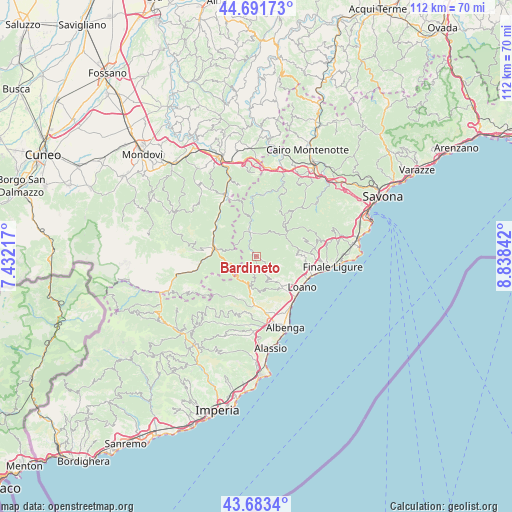
Bardineto GPS coordinates[2]
44° 11' 22.992" North, 8° 8' 7.044" East
| Map corner | latitude | longitude |
|---|---|---|
| Upper-left | 44.69173°, | 7.43217° |
| Center: | 44.18972°, | 8.13529° |
| Lower-right: | 43.6834°, | 8.83842° |
| Map W x H: | 112.1×112.1 km | = 69.7×69.7mi |
| max Lat: | 47.04031° ⇑52.9% North |
| Bardineto: | 44.18972° |
| min Lat: | ⇓47.1% South 35.50142° |
| min Long | Bardineto | max Long |
| 6.69888° | 8.13529° | 18.48682° |
| W 8.2%⇐ | ⇒91.8% E |
Elevation
Elevation of Bardineto is 716 m = 2349 ft, and this is 409.3 m = 1343 ft above average elevation for this country.
| Max E: |
2085 m = 6841 ft | 10.2% |
| Bardineto | 716 m 2349 ft | |
| Avg. | 306.7 m = 1006 ft | |
Min E: |
-4 m = -13 ft | 89.8% |
See also: Italy elevation on elevation.city.
Geographical zone
Bardineto is located in North temperate zone (between Tropic of Cancer and the Arctic Circle). Distance of this Northern Tropic circle is 2307.5 km =1433.8 mi to South.| Distance of | km | miles | from Bardineto |
|---|---|---|---|
| North Pole | 5093.6 | 3165 | to North |
| Arctic Circle | 2487.7 | 1545.8 | to North |
| Tropic Cancer | 2307.5 | 1433.8 | to South |
| Equator | 4913.4 | 3053 | to South |


Nearby cities:
15 places around Bardineto: (largest is in red/bold)
• Balestrino
7.8 km =4.8 mi,  158°
158°
• Boissano
9.1 km =5.7 mi,  131°
131°
• Calizzano
5.3 km =3.3 mi,  345°
345°
• Castelbianco
9.7 km =6 mi,  209°
209°
• Castelvecchio di Rocca Barbena
6.8 km =4.2 mi,  192°
192°
• Erli
6.3 km =3.9 mi,  202°
202°
• Garessio
9.6 km =6 mi,  281°
281°
• Giustenice
8.8 km =5.5 mi,  102°
102°
• Magliolo
9.1 km =5.7 mi,  88°
88°
• Priola
10.9 km =6.8 mi,  304°
304°
• Rialto
10.8 km =6.7 mi,  67°
67°
• San Lorenzo
8.9 km =5.5 mi, 102°
• Toirano
9 km =5.6 mi,  140°
140°
• Tovo San Giacomo
10.9 km =6.8 mi, 98°
• Zuccarello
9 km =5.6 mi, 188°
Sources, notices
• [Note1] Compared only with cities in Italy existing in our database
• [Src1] Map data: © OpenStreetMap contributors (CC-BY-SA)
• [Src2] Other city data from geonames.org with taken over terms of usage.
• [Src3] Geographical zone / Annual Mean Temperature by Robert A. Rohde @ Wikipedia
