Badia Tedalda geodata
Badia Tedalda (Tuscany) is a seat of a third-order administrative division; located in Italy in Europe/Rome (GMT+2) time zone. With population of 378 people, there are 10359 cities with bigger population in this country. Compared to other cities in Italy, 58% of cities are located further ↑North; 58.4% of cities are located further ←West and 89.2% of cities have lower elevation than Badia Tedalda. Note1


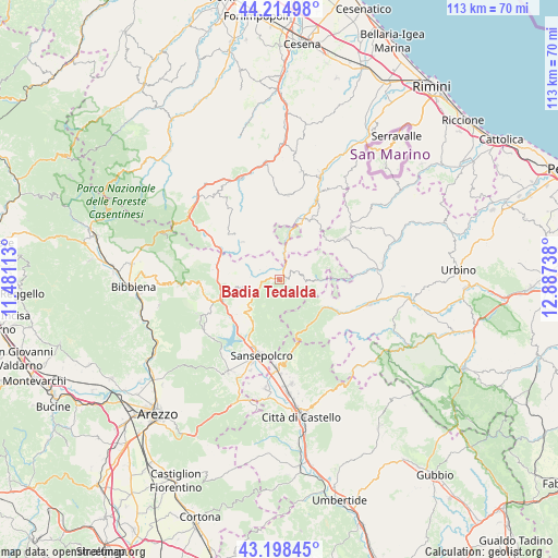
Badia Tedalda GPS coordinates[2]
43° 42' 31.932" North, 12° 11' 3.3" East
| Map corner | latitude | longitude |
|---|---|---|
| Upper-left | 44.21498°, | 11.48113° |
| Center: | 43.70887°, | 12.18425° |
| Lower-right: | 43.19845°, | 12.88738° |
| Map W x H: | 113×113 km | = 70.2×70.2mi |
| max Lat: | 47.04031° ⇑58% North |
| Badia Tedalda: | 43.70887° |
| min Lat: | ⇓42% South 35.50142° |
| min Long | Badia Tedalda | max Long |
| 6.69888° | 12.18425° | 18.48682° |
| W 58.4%⇐ | ⇒41.6% E |
Elevation
Elevation of Badia Tedalda is 699 m = 2293 ft, and this is 392.3 m = 1287 ft above average elevation for this country.
| Max E: |
2085 m = 6841 ft | 10.8% |
| Badia Tedalda | 699 m 2293 ft | |
| Avg. | 306.7 m = 1006 ft | |
Min E: |
-4 m = -13 ft | 89.2% |
See also: Italy elevation on elevation.city.
Geographical zone
Badia Tedalda is located in North temperate zone (between Tropic of Cancer and the Arctic Circle). Distance of this Northern Tropic circle is 2254.1 km =1400.6 mi to South.| Distance of | km | miles | from Badia Tedalda |
|---|---|---|---|
| North Pole | 5147.1 | 3198.3 | to North |
| Arctic Circle | 2541.2 | 1579 | to North |
| Tropic Cancer | 2254.1 | 1400.6 | to South |
| Equator | 4860 | 3019.9 | to South |


Nearby cities:
15 places around Badia Tedalda: (largest is in red/bold)
• Belforte
15.4 km =9.6 mi,  86°
86°
• Borgo Pace
10.4 km =6.5 mi,  122°
122°
• Caprese Michelangelo
17.7 km =11 mi,  244°
244°
• Carpegna
14.6 km =9.1 mi,  56°
56°
• Casteldelci
9.4 km =5.8 mi,  345°
345°
• Frontino
16.7 km =10.4 mi,  68°
68°
• Mercatello sul Metauro
14 km =8.7 mi, 119°
• Pennabilli
13.8 km =8.6 mi,  28°
28°
• Piandimeleto
18.1 km =11.2 mi,  84°
84°
• Pieve Santo Stefano
12.2 km =7.6 mi,  250°
250°
• Sansepolcro
15.6 km =9.7 mi,  193°
193°
• Sant'Agata Feltria
17.2 km =10.7 mi,  6°
6°
• Santa Fiora
17.5 km =10.9 mi,  199°
199°
• Sestino
9.1 km =5.7 mi, 89°
• Verghereto
17.2 km =10.7 mi,  303°
303°
Sources, notices
• [Note1] Compared only with cities in Italy existing in our database
• [Src1] Map data: © OpenStreetMap contributors (CC-BY-SA)
• [Src2] Other city data from geonames.org with taken over terms of usage.
• [Src3] Geographical zone / Annual Mean Temperature by Robert A. Rohde @ Wikipedia
