Casteldelci geodata
Casteldelci (Emilia-Romagna) is a seat of a third-order administrative division; located in Italy in Europe/Rome (GMT+2) time zone. With population of 511 people, there are 9811 cities with bigger population in this country. Compared to other cities in Italy, 57.1% of cities are located further ↑North; 58.1% of cities are located further ←West and 83.6% of cities have lower elevation than Casteldelci. Note1
Administrative division(s):
- Level 1: Emilia-Romagna
- Level 2: Provincia di Rimini
- Level 3: Casteldelci


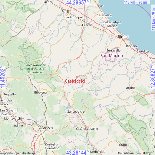
Casteldelci GPS coordinates[2]
43° 47' 28.176" North, 12° 9' 18.504" East
| Map corner | latitude | longitude |
|---|---|---|
| Upper-left | 44.29657°, | 11.45202° |
| Center: | 43.79116°, | 12.15514° |
| Lower-right: | 43.28144°, | 12.85827° |
| Map W x H: | 112.9×112.9 km | = 70.2×70.2mi |
| max Lat: | 47.04031° ⇑57.1% North |
| Casteldelci: | 43.79116° |
| min Lat: | ⇓42.9% South 35.50142° |
| min Long | Casteldelci | max Long |
| 6.69888° | 12.15514° | 18.48682° |
| W 58.1%⇐ | ⇒41.9% E |
Elevation
Elevation of Casteldelci is 582 m = 1909 ft, and this is 275.3 m = 903 ft above average elevation for this country.
| Max E: |
2085 m = 6841 ft | 16.4% |
| Casteldelci | 582 m 1909 ft | |
| Avg. | 306.7 m = 1006 ft | |
Min E: |
-4 m = -13 ft | 83.6% |
See also: Italy elevation on elevation.city.
Geographical zone
Casteldelci is located in North temperate zone (between Tropic of Cancer and the Arctic Circle). Distance of this Northern Tropic circle is 2263.2 km =1406.3 mi to South.| Distance of | km | miles | from Casteldelci |
|---|---|---|---|
| North Pole | 5137.9 | 3192.5 | to North |
| Arctic Circle | 2532.1 | 1573.4 | to North |
| Tropic Cancer | 2263.2 | 1406.3 | to South |
| Equator | 4869.1 | 3025.5 | to South |


Nearby cities:
15 places around Casteldelci: (largest is in red/bold)
• Alfero
10.1 km =6.3 mi,  307°
307°
• Badia Tedalda
9.4 km =5.8 mi,  165°
165°
• Bagno di Romagna
16.4 km =10.2 mi,  287°
287°
• Carpegna
14.5 km =9 mi,  94°
94°
• Novafeltria
15.8 km =9.8 mi,  42°
42°
• Pennabilli
9.4 km =5.8 mi,  71°
71°
• Perticara
14.5 km =9 mi,  28°
28°
• Pieve Santo Stefano
16.2 km =10.1 mi,  214°
214°
• San Piero in Bagno
16.1 km =10 mi,  297°
297°
• Sant'Agata Feltria
9 km =5.6 mi, 27°
• Sarsina
14.3 km =8.9 mi,  355°
355°
• Serra di Maiolo
15.5 km =9.6 mi,  53°
53°
• Sestino
14.6 km =9.1 mi,  128°
128°
• Talamello
16.4 km =10.2 mi, 39°
• Verghereto
12 km =7.5 mi,  271°
271°
Sources, notices
• [Note1] Compared only with cities in Italy existing in our database
• [Src1] Map data: © OpenStreetMap contributors (CC-BY-SA)
• [Src2] Other city data from geonames.org with taken over terms of usage.
• [Src3] Geographical zone / Annual Mean Temperature by Robert A. Rohde @ Wikipedia
