Anguillara Veneta geodata
Anguillara Veneta (Veneto) is a seat of a third-order administrative division; located in Italy in Europe/Rome (GMT+2) time zone. With population of 2,938 people, there are 3092 cities with bigger population in this country. Compared to other cities in Italy, 63.5% of cities are located further ↓South; 54.3% of cities are located further ←West and 99% of cities have higher elevation than Anguillara Veneta. Note1


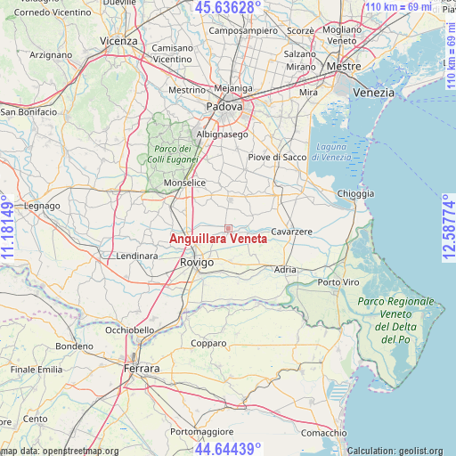
Anguillara Veneta GPS coordinates[2]
45° 8' 32.964" North, 11° 53' 4.596" East
| Map corner | latitude | longitude |
|---|---|---|
| Upper-left | 45.63628°, | 11.18149° |
| Center: | 45.14249°, | 11.88461° |
| Lower-right: | 44.64439°, | 12.58774° |
| Map W x H: | 110.3×110.3 km | = 68.5×68.5mi |
| max Lat: | 47.04031° ⇑36.5% North |
| Anguillara Veneta: | 45.14249° |
| min Lat: | ⇓63.5% South 35.50142° |
| min Long | Anguillara Vene | max Long |
| 6.69888° | 11.88461° | 18.48682° |
| W 54.3%⇐ | ⇒45.7% E |
Elevation
Elevation of Anguillara Veneta is 2 m = 7 ft, and this is 304.7 m = 1000 ft below average elevation for this country.
| Max E: |
2085 m = 6841 ft | 99% |
| Avg. | 306.7 m = 1006 ft | |
| Anguillara Veneta | 2 m = 7 ft | |
Min E: |
-4 m = -13 ft | 1% |
See also: Italy elevation on elevation.city.
Geographical zone
Anguillara Veneta is located in North temperate zone (between Tropic of Cancer and the Arctic Circle). Distance of this North polar circle is 2381.8 km =1480 mi to North.| Distance of | km | miles | from Anguillara Veneta |
|---|---|---|---|
| North Pole | 4987.7 | 3099.2 | to North |
| Arctic Circle | 2381.8 | 1480 | to North |
| Tropic Cancer | 2413.5 | 1499.7 | to South |
| Equator | 5019.4 | 3118.9 | to South |


Nearby cities:
15 places around Anguillara Veneta: (largest is in red/bold)
• Agna
6.4 km =4 mi,  60°
60°
• Arre
9 km =5.6 mi,  22°
22°
• Bagnoli di Sopra
4.9 km =3 mi,  359°
359°
• Beverare
4.9 km =3 mi,  102°
102°
• Boara Pisani
8.9 km =5.5 mi,  244°
244°
• Buso
9.1 km =5.7 mi,  198°
198°
• Conselve
9.9 km =6.2 mi, 355°
• Mardimago
5.4 km =3.4 mi,  223°
223°
• Pettorazza Grimani
8.1 km =5 mi, 95°
• Pozzonovo
9.4 km =5.8 mi,  309°
309°
• Rottanova
10.5 km =6.5 mi,  89°
89°
• San Martino di Venezze
2.2 km =1.4 mi,  210°
210°
• Stanghella
10 km =6.2 mi,  265°
265°
• Tribano
8.3 km =5.2 mi,  332°
332°
• Villadose
7.9 km =4.9 mi,  171°
171°
Sources, notices
• [Note1] Compared only with cities in Italy existing in our database
• [Src1] Map data: © OpenStreetMap contributors (CC-BY-SA)
• [Src2] Other city data from geonames.org with taken over terms of usage.
• [Src3] Geographical zone / Annual Mean Temperature by Robert A. Rohde @ Wikipedia
