Laura geodata
Laura (Campania) is a populated place; located in Italy in Europe/Rome (GMT+2) time zone. With population of 1,624 people, there are 4834 cities with bigger population in this country. Compared to other cities in Italy, 84.5% of cities are located further ↑North; 87.1% of cities are located further ←West and 98.4% of cities have higher elevation than Laura. Note1
Administrative division(s):
- Level 1: Campania
- Level 2: Provincia di Salerno
- Level 3: Capaccio Paestum


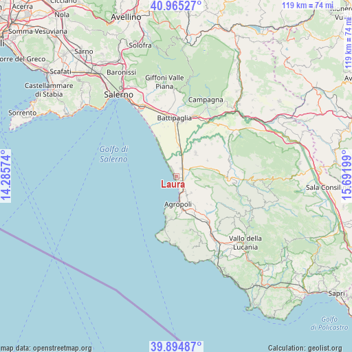
Laura GPS coordinates[2]
40° 25' 55.92" North, 14° 59' 19.896" East
| Map corner | latitude | longitude |
|---|---|---|
| Upper-left | 40.96527°, | 14.28574° |
| Center: | 40.4322°, | 14.98886° |
| Lower-right: | 39.89487°, | 15.69199° |
| Map W x H: | 119×119 km | = 73.9×73.9mi |
| max Lat: | 47.04031° ⇑84.5% North |
| Laura: | 40.4322° |
| min Lat: | ⇓15.5% South 35.50142° |
| min Long | Laura | max Long |
| 6.69888° | 14.98886° | 18.48682° |
| W 87.1%⇐ | ⇒12.9% E |
Elevation
Elevation of Laura is 3 m = 10 ft, and this is 303.7 m = 996 ft below average elevation for this country.
| Max E: |
2085 m = 6841 ft | 98.4% |
| Avg. | 306.7 m = 1006 ft | |
| Laura | 3 m = 10 ft | |
Min E: |
-4 m = -13 ft | 1.6% |
See also: Italy elevation on elevation.city.
Geographical zone
Laura is located in North temperate zone (between Tropic of Cancer and the Arctic Circle). Distance of this Northern Tropic circle is 1889.7 km =1174.2 mi to South.| Distance of | km | miles | from Laura |
|---|---|---|---|
| North Pole | 5511.4 | 3424.6 | to North |
| Arctic Circle | 2905.5 | 1805.4 | to North |
| Tropic Cancer | 1889.7 | 1174.2 | to South |
| Equator | 4495.6 | 2793.4 | to South |


Nearby cities:
15 places around Laura: (largest is in red/bold)
• Agropoli
9.2 km =5.7 mi,  179°
179°
• Albanella
11.9 km =7.4 mi,  63°
63°
• Bivio Santa Cecilia
10.1 km =6.3 mi,  5°
5°
• Cafasso-Borgo Nuovo
2 km =1.2 mi,  70°
70°
• Capaccio
7.7 km =4.8 mi,  96°
96°
• Capaccio Scalo
3.1 km =1.9 mi,  33°
33°
• Giungano
10.9 km =6.8 mi,  112°
112°
• Licinella-Torre di Paestum
2.9 km =1.8 mi,  165°
165°
• Matinella
10.2 km =6.3 mi,  40°
40°
• Mattine
6 km =3.7 mi,  149°
149°
• Ogliastro Cilento
10.2 km =6.3 mi, 151°
• Ponte Barizzo
7.2 km =4.5 mi,  19°
19°
• Rettifilo-Vannullo
3.9 km =2.4 mi, 57°
• Santa Venere
3.1 km =1.9 mi,  140°
140°
• Trentinara
11.3 km =7 mi, 108°
Sources, notices
• [Note1] Compared only with cities in Italy existing in our database
• [Src1] Map data: © OpenStreetMap contributors (CC-BY-SA)
• [Src2] Other city data from geonames.org with taken over terms of usage.
• [Src3] Geographical zone / Annual Mean Temperature by Robert A. Rohde @ Wikipedia
