Oggebbio geodata
Oggebbio (Piedmont) is a seat of a third-order administrative division; located in Italy in Europe/Rome (GMT+2) time zone. With population of 836 people, there are 7467 cities with bigger population in this country. Compared to other cities in Italy, 91.7% of cities are located further ↓South; 86.2% of cities are located further →East and 50.8% of cities have higher elevation than Oggebbio. Note1
Administrative division(s):
- Level 1: Piedmont
- Level 2: Provincia Verbano-Cusio-Ossola
- Level 3: Oggebbio


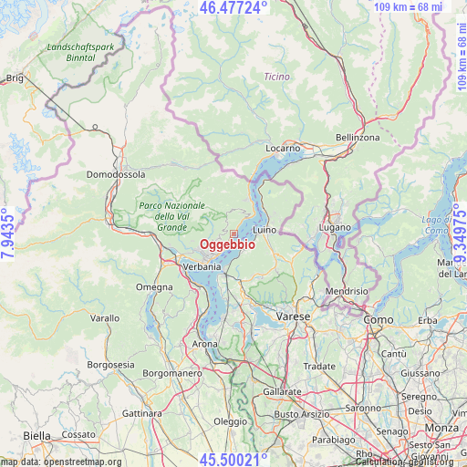
Oggebbio GPS coordinates[2]
45° 59' 27.168" North, 8° 38' 47.868" East
| Map corner | latitude | longitude |
|---|---|---|
| Upper-left | 46.47724°, | 7.9435° |
| Center: | 45.99088°, | 8.64663° |
| Lower-right: | 45.50021°, | 9.34975° |
| Map W x H: | 108.6×108.6 km | = 67.5×67.5mi |
| max Lat: | 47.04031° ⇑8.3% North |
| Oggebbio: | 45.99088° |
| min Lat: | ⇓91.7% South 35.50142° |
| min Long | Oggebbio | max Long |
| 6.69888° | 8.64663° | 18.48682° |
| W 13.8%⇐ | ⇒86.2% E |
Elevation
Elevation of Oggebbio is 230 m = 755 ft, and this is 76.7 m = 252 ft below average elevation for this country.
| Max E: |
2085 m = 6841 ft | 50.8% |
| Avg. | 306.7 m = 1006 ft | |
| Oggebbio | 230 m = 755 ft | |
Min E: |
-4 m = -13 ft | 49.2% |
See also: Italy elevation on elevation.city.
Geographical zone
Oggebbio is located in North temperate zone (between Tropic of Cancer and the Arctic Circle). Distance of this North polar circle is 2287.5 km =1421.4 mi to North.| Distance of | km | miles | from Oggebbio |
|---|---|---|---|
| North Pole | 4893.4 | 3040.6 | to North |
| Arctic Circle | 2287.5 | 1421.4 | to North |
| Tropic Cancer | 2507.8 | 1558.3 | to South |
| Equator | 5113.7 | 3177.5 | to South |


Nearby cities:
15 places around Oggebbio: (largest is in red/bold)
• Arizzano
6.2 km =3.9 mi,  232°
232°
• Aurano
4.6 km =2.9 mi,  283°
283°
• Bedero
5.7 km =3.5 mi,  104°
104°
• Bee
6.3 km =3.9 mi,  240°
240°
• Brezzo di Bedero
5.6 km =3.5 mi, 104°
• Cannero Riviera
4.3 km =2.7 mi,  36°
36°
• Castello
5.1 km =3.2 mi,  153°
153°
• Castelveccana
5 km =3.1 mi,  162°
162°
• Germignaga
6 km =3.7 mi,  89°
89°
• Ghiffa
5.3 km =3.3 mi,  217°
217°
• Gonte
0.5 km =0.3 mi,  27°
27°
• Intragna
5.6 km =3.5 mi,  274°
274°
• Porto Valtravaglia
4.3 km =2.7 mi,  141°
141°
• Premeno
4.2 km =2.6 mi,  250°
250°
• Trarego
5.2 km =3.2 mi,  20°
20°
Sources, notices
• [Note1] Compared only with cities in Italy existing in our database
• [Src1] Map data: © OpenStreetMap contributors (CC-BY-SA)
• [Src2] Other city data from geonames.org with taken over terms of usage.
• [Src3] Geographical zone / Annual Mean Temperature by Robert A. Rohde @ Wikipedia
