Castello geodata
Castello (Lombardy) is a seat of a third-order administrative division; located in Italy in Europe/Rome (GMT+2) time zone. With population of 1,885 people, there are 4346 cities with bigger population in this country. Compared to other cities in Italy, 90.6% of cities are located further ↓South; 85.8% of cities are located further →East and 60.3% of cities have lower elevation than Castello. Note1


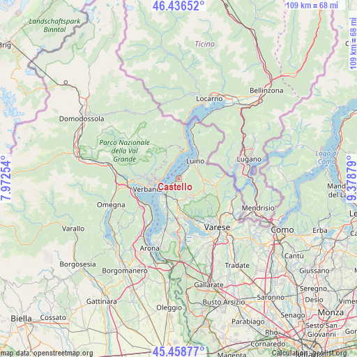
Castello GPS coordinates[2]
45° 56' 59.28" North, 8° 40' 32.376" East
| Map corner | latitude | longitude |
|---|---|---|
| Upper-left | 46.43652°, | 7.97254° |
| Center: | 45.9498°, | 8.67566° |
| Lower-right: | 45.45877°, | 9.37879° |
| Map W x H: | 108.7×108.7 km | = 67.5×67.5mi |
| max Lat: | 47.04031° ⇑9.4% North |
| Castello: | 45.9498° |
| min Lat: | ⇓90.6% South 35.50142° |
| min Long | Castello | max Long |
| 6.69888° | 8.67566° | 18.48682° |
| W 14.2%⇐ | ⇒85.8% E |
Elevation
Elevation of Castello is 301 m = 988 ft, and this is 5.7 m = 19 ft below average elevation for this country.
| Max E: |
2085 m = 6841 ft | 39.7% |
| Avg. | 306.7 m = 1006 ft | |
| Castello | 301 m = 988 ft | |
Min E: |
-4 m = -13 ft | 60.3% |
See also: Italy elevation on elevation.city.
Geographical zone
Castello is located in North temperate zone (between Tropic of Cancer and the Arctic Circle). Distance of this North polar circle is 2292 km =1424.2 mi to North.| Distance of | km | miles | from Castello |
|---|---|---|---|
| North Pole | 4897.9 | 3043.4 | to North |
| Arctic Circle | 2292 | 1424.2 | to North |
| Tropic Cancer | 2503.2 | 1555.4 | to South |
| Equator | 5109.1 | 3174.6 | to South |


Nearby cities:
15 places around Castello: (largest is in red/bold)
• Bedero
4.5 km =2.8 mi,  46°
46°
• Brenta
6.2 km =3.9 mi,  174°
174°
• Brezzo di Bedero
4.5 km =2.8 mi, 45°
• Brissago-Valtravaglia
5.4 km =3.4 mi,  90°
90°
• Casalzuigno
5.6 km =3.5 mi,  152°
152°
• Castelveccana
0.7 km =0.4 mi,  254°
254°
• Cittiglio
6 km =3.7 mi,  187°
187°
• Duno
6.2 km =3.9 mi,  129°
129°
• Germignaga
5.9 km =3.7 mi,  39°
39°
• Ghiffa
5.5 km =3.4 mi,  273°
273°
• Gonte
5.4 km =3.4 mi,  338°
338°
• Laveno
6.2 km =3.9 mi,  223°
223°
• Oggebbio
5.1 km =3.2 mi,  333°
333°
• Piano
6.2 km =3.9 mi,  75°
75°
• Porto Valtravaglia
1.3 km =0.8 mi,  18°
18°
Sources, notices
• [Note1] Compared only with cities in Italy existing in our database
• [Src1] Map data: © OpenStreetMap contributors (CC-BY-SA)
• [Src2] Other city data from geonames.org with taken over terms of usage.
• [Src3] Geographical zone / Annual Mean Temperature by Robert A. Rohde @ Wikipedia
