Allein geodata
Allein (Aosta Valley) is a seat of a third-order administrative division; located in Italy in Europe/Rome (GMT+2) time zone. With population of 65 people, there are 11552 cities with bigger population in this country. Compared to other cities in Italy, 86% of cities are located further ↓South; 99.1% of cities are located further →East and 98.7% of cities have lower elevation than Allein. Note1


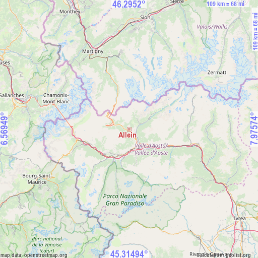
Allein GPS coordinates[2]
45° 48' 26.028" North, 7° 16' 21.432" East
| Map corner | latitude | longitude |
|---|---|---|
| Upper-left | 46.2952°, | 6.56949° |
| Center: | 45.80723°, | 7.27262° |
| Lower-right: | 45.31494°, | 7.97574° |
| Map W x H: | 109×109 km | = 67.7×67.7mi |
| max Lat: | 47.04031° ⇑14% North |
| Allein: | 45.80723° |
| min Lat: | ⇓86% South 35.50142° |
| min Long | Allein | max Long |
| 6.69888° | 7.27262° | 18.48682° |
| W 0.9%⇐ | ⇒99.1% E |
Elevation
Elevation of Allein is 1215 m = 3986 ft, and this is 908.3 m = 2980 ft above average elevation for this country.
| Max E: |
2085 m = 6841 ft | 1.3% |
| Allein | 1215 m 3986 ft | |
| Avg. | 306.7 m = 1006 ft | |
Min E: |
-4 m = -13 ft | 98.7% |
See also: Italy elevation on elevation.city.
Geographical zone
Allein is located in North temperate zone (between Tropic of Cancer and the Arctic Circle). Distance of this North polar circle is 2307.9 km =1434.1 mi to North.| Distance of | km | miles | from Allein |
|---|---|---|---|
| North Pole | 4913.8 | 3053.3 | to North |
| Arctic Circle | 2307.9 | 1434.1 | to North |
| Tropic Cancer | 2487.4 | 1545.6 | to South |
| Equator | 5093.3 | 3164.8 | to South |


Nearby cities:
15 places around Allein: (largest is in red/bold)
• Aosta
8.5 km =5.3 mi,  155°
155°
• Arpuilles
6.4 km =4 mi, 156°
• Doues
2.9 km =1.8 mi,  62°
62°
• Etroubles
3.5 km =2.2 mi,  295°
295°
• Gignod
3.5 km =2.2 mi,  148°
148°
• La Cretaz-Roisan
4.1 km =2.5 mi,  129°
129°
• Ollomont
5.6 km =3.5 mi,  31°
31°
• Porossan
7.1 km =4.4 mi,  143°
143°
• Saint-Christophe
8.3 km =5.2 mi, 135°
• Saint-Oyen
4.9 km =3 mi,  292°
292°
• Saint-Rhémy
7.6 km =4.7 mi, 294°
• San Leonardo
7.3 km =4.5 mi,  284°
284°
• Valpelline
4.5 km =2.8 mi, 64°
• Variney Chez Roncoz
5.2 km =3.2 mi, 145°
• Ville Sur Sarre
8.3 km =5.2 mi,  187°
187°
Sources, notices
• [Note1] Compared only with cities in Italy existing in our database
• [Src1] Map data: © OpenStreetMap contributors (CC-BY-SA)
• [Src2] Other city data from geonames.org with taken over terms of usage.
• [Src3] Geographical zone / Annual Mean Temperature by Robert A. Rohde @ Wikipedia
