Ollomont geodata
Ollomont (Aosta Valley) is a seat of a third-order administrative division; located in Italy in Europe/Rome (GMT+2) time zone. With population of 62 people, there are 11565 cities with bigger population in this country. Compared to other cities in Italy, 87.7% of cities are located further ↓South; 98.9% of cities are located further →East and 99.4% of cities have lower elevation than Ollomont. Note1


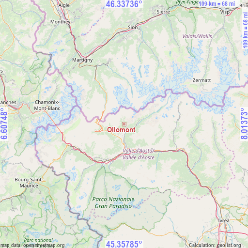
Ollomont GPS coordinates[2]
45° 50' 59.136" North, 7° 18' 38.16" East
| Map corner | latitude | longitude |
|---|---|---|
| Upper-left | 46.33736°, | 6.60748° |
| Center: | 45.84976°, | 7.3106° |
| Lower-right: | 45.35785°, | 8.01373° |
| Map W x H: | 108.9×108.9 km | = 67.7×67.7mi |
| max Lat: | 47.04031° ⇑12.3% North |
| Ollomont: | 45.84976° |
| min Lat: | ⇓87.7% South 35.50142° |
| min Long | Ollomont | max Long |
| 6.69888° | 7.3106° | 18.48682° |
| W 1.1%⇐ | ⇒98.9% E |
Elevation
Elevation of Ollomont is 1375 m = 4511 ft, and this is 1068.3 m = 3505 ft above average elevation for this country.
| Max E: |
2085 m = 6841 ft | 0.59999999999999% |
| Ollomont | 1375 m 4511 ft | |
| Avg. | 306.7 m = 1006 ft | |
Min E: |
-4 m = -13 ft | 99.4% |
See also: Italy elevation on elevation.city.
Geographical zone
Ollomont is located in North temperate zone (between Tropic of Cancer and the Arctic Circle). Distance of this North polar circle is 2303.2 km =1431.1 mi to North.| Distance of | km | miles | from Ollomont |
|---|---|---|---|
| North Pole | 4909 | 3050.3 | to North |
| Arctic Circle | 2303.2 | 1431.1 | to North |
| Tropic Cancer | 2492.1 | 1548.5 | to South |
| Equator | 5098 | 3167.7 | to South |


Nearby cities:
15 places around Ollomont: (largest is in red/bold)
• Allein
5.6 km =3.5 mi,  211°
211°
• Arpuilles
10.6 km =6.6 mi,  181°
181°
• Bionaz
9.1 km =5.7 mi,  73°
73°
• Doues
3.4 km =2.1 mi,  185°
185°
• Etroubles
6.9 km =4.3 mi,  242°
242°
• Gignod
7.8 km =4.8 mi, 188°
• La Cretaz-Roisan
7.3 km =4.5 mi, 178°
• Oyace
5.6 km =3.5 mi,  88°
88°
• Porossan
10.5 km =6.5 mi,  173°
173°
• Saint-Christophe
11 km =6.8 mi, 165°
• Saint-Oyen
8 km =5 mi,  249°
249°
• Saint-Rhémy
9.9 km =6.2 mi,  260°
260°
• San Leonardo
10.4 km =6.5 mi, 253°
• Valpelline
3 km =1.9 mi,  157°
157°
• Variney Chez Roncoz
9 km =5.6 mi, 180°
Sources, notices
• [Note1] Compared only with cities in Italy existing in our database
• [Src1] Map data: © OpenStreetMap contributors (CC-BY-SA)
• [Src2] Other city data from geonames.org with taken over terms of usage.
• [Src3] Geographical zone / Annual Mean Temperature by Robert A. Rohde @ Wikipedia
