Cesi geodata
Cesi (Umbria) is a populated place; located in Italy in Europe/Rome (GMT+2) time zone. With population of 640 people, there are 8704 cities with bigger population in this country. Compared to other cities in Italy, 65.7% of cities are located further ↑North; 63.4% of cities are located further ←West and 74.7% of cities have lower elevation than Cesi. Note1


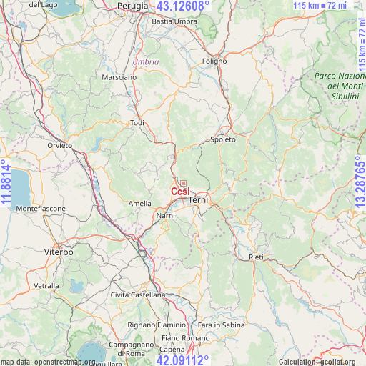
Cesi GPS coordinates[2]
42° 36' 38.7" North, 12° 35' 4.272" East
| Map corner | latitude | longitude |
|---|---|---|
| Upper-left | 43.12608°, | 11.8814° |
| Center: | 42.61075°, | 12.58452° |
| Lower-right: | 42.09112°, | 13.28765° |
| Map W x H: | 115.1×115.1 km | = 71.5×71.5mi |
| max Lat: | 47.04031° ⇑65.7% North |
| Cesi: | 42.61075° |
| min Lat: | ⇓34.3% South 35.50142° |
| min Long | Cesi | max Long |
| 6.69888° | 12.58452° | 18.48682° |
| W 63.4%⇐ | ⇒36.6% E |
Elevation
Elevation of Cesi is 448 m = 1470 ft, and this is 141.3 m = 464 ft above average elevation for this country.
| Max E: |
2085 m = 6841 ft | 25.3% |
| Cesi | 448 m 1470 ft | |
| Avg. | 306.7 m = 1006 ft | |
Min E: |
-4 m = -13 ft | 74.7% |
See also: Italy elevation on elevation.city.
Geographical zone
Cesi is located in North temperate zone (between Tropic of Cancer and the Arctic Circle). Distance of this Northern Tropic circle is 2132 km =1324.8 mi to South.| Distance of | km | miles | from Cesi |
|---|---|---|---|
| North Pole | 5269.2 | 3274.1 | to North |
| Arctic Circle | 2663.3 | 1654.9 | to North |
| Tropic Cancer | 2132 | 1324.8 | to South |
| Equator | 4737.9 | 2944 | to South |


Nearby cities:
15 places around Cesi: (largest is in red/bold)
• Acquasparta
9.4 km =5.8 mi,  338°
338°
• Avigliano Umbro
13.8 km =8.6 mi,  289°
289°
• Casteltodino
9.3 km =5.8 mi,  311°
311°
• Fornole
13 km =8.1 mi,  234°
234°
• Marmore
12.7 km =7.9 mi,  123°
123°
• Montecastrilli
9.1 km =5.7 mi,  299°
299°
• Montefranco
14.7 km =9.1 mi,  95°
95°
• Narni
11.2 km =7 mi,  204°
204°
• Narni Scalo
10 km =6.2 mi,  213°
213°
• Ponte San Lorenzo
8.4 km =5.2 mi,  182°
182°
• Roman catholic diocese of Terni
7.3 km =4.5 mi,  139°
139°
• San Gemini
3.2 km =2 mi,  275°
275°
• Stroncone
12.1 km =7.5 mi,  154°
154°
• Terni
7.1 km =4.4 mi, 137°
• Testaccio
13.6 km =8.5 mi, 202°
Sources, notices
• [Note1] Compared only with cities in Italy existing in our database
• [Src1] Map data: © OpenStreetMap contributors (CC-BY-SA)
• [Src2] Other city data from geonames.org with taken over terms of usage.
• [Src3] Geographical zone / Annual Mean Temperature by Robert A. Rohde @ Wikipedia
