Narni Scalo geodata
Narni Scalo (Umbria) is a populated place; located in Italy in Europe/Rome (GMT+2) time zone. With population of 5,010 people, there are 1949 cities with bigger population in this country. Compared to other cities in Italy, 66.1% of cities are located further ↑North; 62.6% of cities are located further ←West and 69.6% of cities have higher elevation than Narni Scalo. Note1


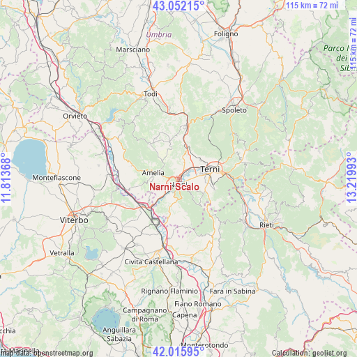
Narni Scalo GPS coordinates[2]
42° 32' 10.32" North, 12° 31' 0.48" East
| Map corner | latitude | longitude |
|---|---|---|
| Upper-left | 43.05215°, | 11.81368° |
| Center: | 42.5362°, | 12.5168° |
| Lower-right: | 42.01595°, | 13.21993° |
| Map W x H: | 115.2×115.2 km | = 71.6×71.6mi |
| max Lat: | 47.04031° ⇑66.1% North |
| Narni Scalo: | 42.5362° |
| min Lat: | ⇓33.9% South 35.50142° |
| min Long | Narni Scalo | max Long |
| 6.69888° | 12.5168° | 18.48682° |
| W 62.6%⇐ | ⇒37.4% E |
Elevation
Elevation of Narni Scalo is 100 m = 328 ft, and this is 206.7 m = 678 ft below average elevation for this country.
| Max E: |
2085 m = 6841 ft | 69.6% |
| Avg. | 306.7 m = 1006 ft | |
| Narni Scalo | 100 m = 328 ft | |
Min E: |
-4 m = -13 ft | 30.4% |
See also: Italy elevation on elevation.city.
Geographical zone
Narni Scalo is located in North temperate zone (between Tropic of Cancer and the Arctic Circle). Distance of this Northern Tropic circle is 2123.7 km =1319.6 mi to South.| Distance of | km | miles | from Narni Scalo |
|---|---|---|---|
| North Pole | 5277.5 | 3279.3 | to North |
| Arctic Circle | 2671.6 | 1660.1 | to North |
| Tropic Cancer | 2123.7 | 1319.6 | to South |
| Equator | 4729.6 | 2938.8 | to South |


Nearby cities:
15 places around Narni Scalo: (largest is in red/bold)
• Amelia
8.1 km =5 mi,  282°
282°
• Cesi
10 km =6.2 mi,  33°
33°
• Fornole
5 km =3.1 mi, 277°
• Montecastrilli
13 km =8.1 mi,  349°
349°
• Narni
2.1 km =1.3 mi,  154°
154°
• Orte
13.6 km =8.5 mi,  232°
232°
• Otricoli
13.2 km =8.2 mi,  194°
194°
• Penna in Teverina
13.8 km =8.6 mi,  249°
249°
• Ponte San Lorenzo
5.2 km =3.2 mi,  90°
90°
• Roman catholic diocese of Terni
10.7 km =6.6 mi,  75°
75°
• San Gemini
8.9 km =5.5 mi,  15°
15°
• San Liberato
8.7 km =5.4 mi, 225°
• Stroncone
11.1 km =6.9 mi,  104°
104°
• Terni
10.8 km =6.7 mi,  73°
73°
• Testaccio
4.3 km =2.7 mi,  174°
174°
Sources, notices
• [Note1] Compared only with cities in Italy existing in our database
• [Src1] Map data: © OpenStreetMap contributors (CC-BY-SA)
• [Src2] Other city data from geonames.org with taken over terms of usage.
• [Src3] Geographical zone / Annual Mean Temperature by Robert A. Rohde @ Wikipedia
