Narni geodata
Narni (Umbria) is a seat of a third-order administrative division; located in Italy in Europe/Rome (GMT+2) time zone. With population of 5,279 people, there are 1847 cities with bigger population in this country. Compared to other cities in Italy, 66.2% of cities are located further ↑North; 62.7% of cities are located further ←West and 62.4% of cities have higher elevation than Narni. Note1


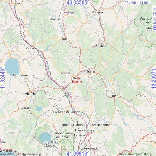
Narni GPS coordinates[2]
42° 31' 10.416" North, 12° 31' 39.288" East
| Map corner | latitude | longitude |
|---|---|---|
| Upper-left | 43.03565°, | 11.82446° |
| Center: | 42.51956°, | 12.52758° |
| Lower-right: | 41.99918°, | 13.23071° |
| Map W x H: | 115.2×115.2 km | = 71.6×71.6mi |
| max Lat: | 47.04031° ⇑66.2% North |
| Narni: | 42.51956° |
| min Lat: | ⇓33.8% South 35.50142° |
| min Long | Narni | max Long |
| 6.69888° | 12.52758° | 18.48682° |
| W 62.7%⇐ | ⇒37.3% E |
Elevation
Elevation of Narni is 146 m = 479 ft, and this is 160.7 m = 527 ft below average elevation for this country.
| Max E: |
2085 m = 6841 ft | 62.4% |
| Avg. | 306.7 m = 1006 ft | |
| Narni | 146 m = 479 ft | |
Min E: |
-4 m = -13 ft | 37.6% |
See also: Italy elevation on elevation.city.
Geographical zone
Narni is located in North temperate zone (between Tropic of Cancer and the Arctic Circle). Distance of this Northern Tropic circle is 2121.8 km =1318.4 mi to South.| Distance of | km | miles | from Narni |
|---|---|---|---|
| North Pole | 5279.3 | 3280.4 | to North |
| Arctic Circle | 2673.4 | 1661.2 | to North |
| Tropic Cancer | 2121.8 | 1318.4 | to South |
| Equator | 4727.7 | 2937.7 | to South |


Nearby cities:
15 places around Narni: (largest is in red/bold)
• Amelia
9.5 km =5.9 mi,  292°
292°
• Calvi dell'Umbria
13.2 km =8.2 mi,  165°
165°
• Cesi
11.2 km =7 mi,  24°
24°
• Fornole
6.4 km =4 mi, 293°
• Narni Scalo
2.1 km =1.3 mi,  334°
334°
• Orte
13.3 km =8.3 mi,  240°
240°
• Orte Scalo
13.6 km =8.5 mi,  226°
226°
• Otricoli
11.7 km =7.3 mi,  200°
200°
• Ponte San Lorenzo
4.6 km =2.9 mi,  67°
67°
• Roman catholic diocese of Terni
10.5 km =6.5 mi,  64°
64°
• San Gemini
10.6 km =6.6 mi,  7°
7°
• San Liberato
8.3 km =5.2 mi, 238°
• Stroncone
9.9 km =6.2 mi,  94°
94°
• Terni
10.7 km =6.6 mi, 62°
• Testaccio
2.5 km =1.6 mi,  190°
190°
Sources, notices
• [Note1] Compared only with cities in Italy existing in our database
• [Src1] Map data: © OpenStreetMap contributors (CC-BY-SA)
• [Src2] Other city data from geonames.org with taken over terms of usage.
• [Src3] Geographical zone / Annual Mean Temperature by Robert A. Rohde @ Wikipedia
