Monti geodata
Monti (Tuscany) is a populated place; located in Italy in Europe/Rome (GMT+2) time zone. With population of 1,369 people, there are 5443 cities with bigger population in this country. Compared to other cities in Italy, 52.3% of cities are located further ↑North; 67.7% of cities are located further →East and 61.2% of cities have higher elevation than Monti. Note1
Administrative division(s):
- Level 1: Tuscany
- Level 2: Provincia di Massa-Carrara
- Level 3: Licciana Nardi


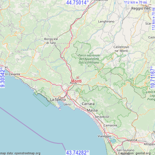
Monti GPS coordinates[2]
44° 14' 55.104" North, 10° 0' 30.744" East
| Map corner | latitude | longitude |
|---|---|---|
| Upper-left | 44.75014°, | 9.30542° |
| Center: | 44.24864°, | 10.00854° |
| Lower-right: | 43.74282°, | 10.71167° |
| Map W x H: | 112×112 km | = 69.6×69.6mi |
| max Lat: | 47.04031° ⇑52.3% North |
| Monti: | 44.24864° |
| min Lat: | ⇓47.7% South 35.50142° |
| min Long | Monti | max Long |
| 6.69888° | 10.00854° | 18.48682° |
| W 32.3%⇐ | ⇒67.7% E |
Elevation
Elevation of Monti is 154 m = 505 ft, and this is 152.7 m = 501 ft below average elevation for this country.
| Max E: |
2085 m = 6841 ft | 61.2% |
| Avg. | 306.7 m = 1006 ft | |
| Monti | 154 m = 505 ft | |
Min E: |
-4 m = -13 ft | 38.8% |
See also: Italy elevation on elevation.city.
Geographical zone
Monti is located in North temperate zone (between Tropic of Cancer and the Arctic Circle). Distance of this Northern Tropic circle is 2314.1 km =1437.9 mi to South.| Distance of | km | miles | from Monti |
|---|---|---|---|
| North Pole | 5087.1 | 3161 | to North |
| Arctic Circle | 2481.2 | 1541.7 | to North |
| Tropic Cancer | 2314.1 | 1437.9 | to South |
| Equator | 4920 | 3057.1 | to South |


Nearby cities:
15 places around Monti: (largest is in red/bold)
• Albiano Magra
10.9 km =6.8 mi,  222°
222°
• Aulla
5.3 km =3.3 mi,  206°
206°
• Bagnone
7.4 km =4.6 mi,  351°
351°
• Barbarasco
5.1 km =3.2 mi,  260°
260°
• Fivizzano
9.5 km =5.9 mi,  97°
97°
• Gragnola
10.1 km =6.3 mi,  126°
126°
• Licciana Nardi
2.9 km =1.8 mi,  51°
51°
• Masero
3.9 km =2.4 mi,  232°
232°
• Montale
6.9 km =4.3 mi, 227°
• Pallerone
4.9 km =3 mi,  185°
185°
• Podenzana
7.1 km =4.4 mi, 228°
• Stallone-Talavorno
10.5 km =6.5 mi,  315°
315°
• Terrarossa
4.1 km =2.5 mi,  246°
246°
• Tresana
7.6 km =4.7 mi,  274°
274°
• Villafranca in Lunigiana
7.1 km =4.4 mi, 321°
Sources, notices
• [Note1] Compared only with cities in Italy existing in our database
• [Src1] Map data: © OpenStreetMap contributors (CC-BY-SA)
• [Src2] Other city data from geonames.org with taken over terms of usage.
• [Src3] Geographical zone / Annual Mean Temperature by Robert A. Rohde @ Wikipedia
