Masero geodata
Masero (Tuscany) is a populated place; located in Italy in Europe/Rome (GMT+2) time zone. With population of 604 people, there are 8960 cities with bigger population in this country. Compared to other cities in Italy, 52.5% of cities are located further ↑North; 68.1% of cities are located further →East and 75.2% of cities have higher elevation than Masero. Note1
Administrative division(s):
- Level 1: Tuscany
- Level 2: Provincia di Massa-Carrara
- Level 3: Licciana Nardi


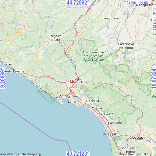
Masero GPS coordinates[2]
44° 13' 38.028" North, 9° 58' 12.396" East
| Map corner | latitude | longitude |
|---|---|---|
| Upper-left | 44.72892°, | 9.26699° |
| Center: | 44.22723°, | 9.97011° |
| Lower-right: | 43.72123°, | 10.67324° |
| Map W x H: | 112×112 km | = 69.6×69.6mi |
| max Lat: | 47.04031° ⇑52.5% North |
| Masero: | 44.22723° |
| min Lat: | ⇓47.5% South 35.50142° |
| min Long | Masero | max Long |
| 6.69888° | 9.97011° | 18.48682° |
| W 31.9%⇐ | ⇒68.1% E |
Elevation
Elevation of Masero is 73 m = 240 ft, and this is 233.7 m = 767 ft below average elevation for this country.
| Max E: |
2085 m = 6841 ft | 75.2% |
| Avg. | 306.7 m = 1006 ft | |
| Masero | 73 m = 240 ft | |
Min E: |
-4 m = -13 ft | 24.8% |
See also: Italy elevation on elevation.city.
Geographical zone
Masero is located in North temperate zone (between Tropic of Cancer and the Arctic Circle). Distance of this Northern Tropic circle is 2311.7 km =1436.4 mi to South.| Distance of | km | miles | from Masero |
|---|---|---|---|
| North Pole | 5089.5 | 3162.5 | to North |
| Arctic Circle | 2483.6 | 1543.2 | to North |
| Tropic Cancer | 2311.7 | 1436.4 | to South |
| Equator | 4917.6 | 3055.7 | to South |


Nearby cities:
15 places around Masero: (largest is in red/bold)
• Albiano Magra
7.2 km =4.5 mi,  216°
216°
• Aulla
2.4 km =1.5 mi,  163°
163°
• Bagnone
10 km =6.2 mi,  11°
11°
• Barbarasco
2.5 km =1.6 mi,  309°
309°
• Bolano
7.4 km =4.6 mi,  233°
233°
• Ceparana-Carpena
9.7 km =6 mi, 225°
• Licciana Nardi
6.8 km =4.2 mi,  52°
52°
• Montale
3.1 km =1.9 mi, 220°
• Monti
3.9 km =2.4 mi, 52°
• Pallerone
3.6 km =2.2 mi,  133°
133°
• Podenzana
3.2 km =2 mi, 223°
• Santo Stefano di Magra
9.5 km =5.9 mi,  203°
203°
• Terrarossa
1 km =0.6 mi, 314°
• Tresana
5.5 km =3.4 mi,  303°
303°
• Villafranca in Lunigiana
8 km =5 mi,  350°
350°
Sources, notices
• [Note1] Compared only with cities in Italy existing in our database
• [Src1] Map data: © OpenStreetMap contributors (CC-BY-SA)
• [Src2] Other city data from geonames.org with taken over terms of usage.
• [Src3] Geographical zone / Annual Mean Temperature by Robert A. Rohde @ Wikipedia
