Tresana geodata
Tresana (Tuscany) is a seat of a third-order administrative division; located in Italy in Europe/Rome (GMT+2) time zone. With population of 99 people, there are 11443 cities with bigger population in this country. Compared to other cities in Italy, 52.3% of cities are located further ↑North; 68.7% of cities are located further →East and 60.4% of cities have higher elevation than Tresana. Note1


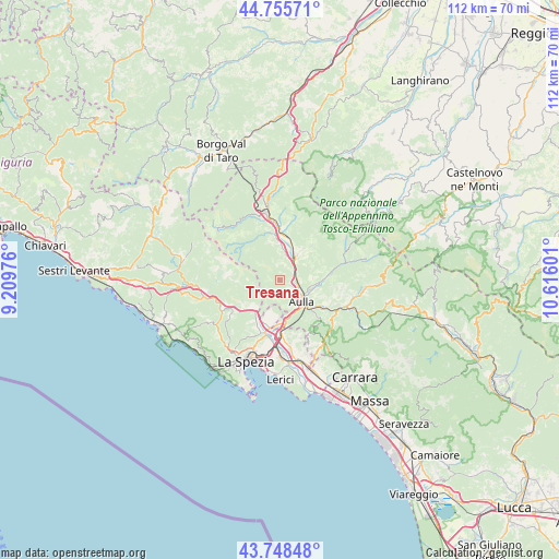
Tresana GPS coordinates[2]
44° 15' 15.3" North, 9° 54' 46.368" East
| Map corner | latitude | longitude |
|---|---|---|
| Upper-left | 44.75571°, | 9.20976° |
| Center: | 44.25425°, | 9.91288° |
| Lower-right: | 43.74848°, | 10.61601° |
| Map W x H: | 112×112 km | = 69.6×69.6mi |
| max Lat: | 47.04031° ⇑52.3% North |
| Tresana: | 44.25425° |
| min Lat: | ⇓47.7% South 35.50142° |
| min Long | Tresana | max Long |
| 6.69888° | 9.91288° | 18.48682° |
| W 31.3%⇐ | ⇒68.7% E |
Elevation
Elevation of Tresana is 160 m = 525 ft, and this is 146.7 m = 481 ft below average elevation for this country.
| Max E: |
2085 m = 6841 ft | 60.4% |
| Avg. | 306.7 m = 1006 ft | |
| Tresana | 160 m = 525 ft | |
Min E: |
-4 m = -13 ft | 39.6% |
See also: Italy elevation on elevation.city.
Geographical zone
Tresana is located in North temperate zone (between Tropic of Cancer and the Arctic Circle). Distance of this Northern Tropic circle is 2314.7 km =1438.3 mi to South.| Distance of | km | miles | from Tresana |
|---|---|---|---|
| North Pole | 5086.5 | 3160.6 | to North |
| Arctic Circle | 2480.6 | 1541.4 | to North |
| Tropic Cancer | 2314.7 | 1438.3 | to South |
| Equator | 4920.6 | 3057.5 | to South |


Nearby cities:
15 places around Tresana: (largest is in red/bold)
• Arpiola-Pianfurcano
7.6 km =4.7 mi,  356°
356°
• Aulla
7.5 km =4.7 mi,  135°
135°
• Barbarasco
3 km =1.9 mi,  118°
118°
• Bolano
7.5 km =4.7 mi,  190°
190°
• Calice al Cornoviglio
6.2 km =3.9 mi,  258°
258°
• Filattiera
8.6 km =5.3 mi,  10°
10°
• Masero
5.5 km =3.4 mi, 123°
• Montale
5.9 km =3.7 mi,  154°
154°
• Monti
7.6 km =4.7 mi,  94°
94°
• Mulazzo
7 km =4.3 mi,  345°
345°
• Piana Battolla
8.3 km =5.2 mi,  214°
214°
• Podenzana
5.8 km =3.6 mi,  156°
156°
• Stallone-Talavorno
6.9 km =4.3 mi,  2°
2°
• Terrarossa
4.5 km =2.8 mi, 120°
• Villafranca in Lunigiana
5.9 km =3.7 mi,  33°
33°
Sources, notices
• [Note1] Compared only with cities in Italy existing in our database
• [Src1] Map data: © OpenStreetMap contributors (CC-BY-SA)
• [Src2] Other city data from geonames.org with taken over terms of usage.
• [Src3] Geographical zone / Annual Mean Temperature by Robert A. Rohde @ Wikipedia
