Feriole geodata
Feriole (Veneto) is a populated place; located in Italy in Europe/Rome (GMT+2) time zone. With population of 946 people, there are 6880 cities with bigger population in this country. Compared to other cities in Italy, 69.6% of cities are located further ↓South; 52.5% of cities are located further ←West and 91.5% of cities have higher elevation than Feriole. Note1


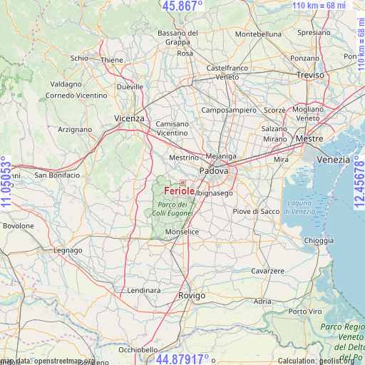
Feriole GPS coordinates[2]
45° 22' 30.864" North, 11° 45' 13.14" East
| Map corner | latitude | longitude |
|---|---|---|
| Upper-left | 45.867°, | 11.05053° |
| Center: | 45.37524°, | 11.75365° |
| Lower-right: | 44.87917°, | 12.45678° |
| Map W x H: | 109.8×109.8 km | = 68.2×68.2mi |
| max Lat: | 47.04031° ⇑30.4% North |
| Feriole: | 45.37524° |
| min Lat: | ⇓69.6% South 35.50142° |
| min Long | Feriole | max Long |
| 6.69888° | 11.75365° | 18.48682° |
| W 52.5%⇐ | ⇒47.5% E |
Elevation
Elevation of Feriole is 15 m = 49 ft, and this is 291.7 m = 957 ft below average elevation for this country.
| Max E: |
2085 m = 6841 ft | 91.5% |
| Avg. | 306.7 m = 1006 ft | |
| Feriole | 15 m = 49 ft | |
Min E: |
-4 m = -13 ft | 8.5% |
See also: Italy elevation on elevation.city.
Geographical zone
Feriole is located in North temperate zone (between Tropic of Cancer and the Arctic Circle). Distance of this North polar circle is 2355.9 km =1463.9 mi to North.| Distance of | km | miles | from Feriole |
|---|---|---|---|
| North Pole | 4961.8 | 3083.1 | to North |
| Arctic Circle | 2355.9 | 1463.9 | to North |
| Tropic Cancer | 2439.3 | 1515.7 | to South |
| Equator | 5045.3 | 3135 | to South |


Nearby cities:
15 places around Feriole: (largest is in red/bold)
• Abano Terme
3.3 km =2.1 mi,  126°
126°
• Canton Madonna
5.4 km =3.4 mi,  10°
10°
• Caselle
6.3 km =3.9 mi,  50°
50°
• Mestrino
7.4 km =4.6 mi,  3°
3°
• Montegrotto Terme
5.5 km =3.4 mi,  152°
152°
• Montemerlo
3.6 km =2.2 mi,  279°
279°
• Rubano
6.3 km =3.9 mi,  28°
28°
• Saccolongo
2.9 km =1.8 mi,  352°
352°
• San Biagio
1.3 km =0.8 mi,  269°
269°
• San Marco
4.7 km =2.9 mi,  329°
329°
• Sarmeola
7.3 km =4.5 mi,  42°
42°
• Selvazzano Dentro
3.3 km =2.1 mi,  65°
65°
• Tencarola
4.9 km =3 mi,  63°
63°
• Torreglia
4.6 km =2.9 mi,  197°
197°
• Treponti
3.6 km =2.2 mi,  255°
255°
Sources, notices
• [Note1] Compared only with cities in Italy existing in our database
• [Src1] Map data: © OpenStreetMap contributors (CC-BY-SA)
• [Src2] Other city data from geonames.org with taken over terms of usage.
• [Src3] Geographical zone / Annual Mean Temperature by Robert A. Rohde @ Wikipedia
