Fellegara geodata
Fellegara (Emilia-Romagna) is a populated place; located in Italy in Europe/Rome (GMT+2) time zone. With population of 1,017 people, there are 6596 cities with bigger population in this country. Compared to other cities in Italy, 52.7% of cities are located further ↓South; 60.9% of cities are located further →East and 73% of cities have higher elevation than Fellegara. Note1
Administrative division(s):
- Level 1: Emilia-Romagna
- Level 2: Provincia di Reggio Emilia
- Level 3: Scandiano


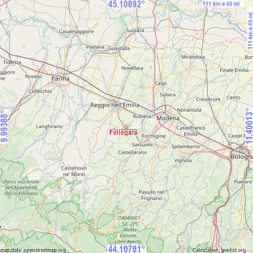
Fellegara GPS coordinates[2]
44° 36' 37.872" North, 10° 41' 49.2" East
| Map corner | latitude | longitude |
|---|---|---|
| Upper-left | 45.10892°, | 9.99388° |
| Center: | 44.61052°, | 10.697° |
| Lower-right: | 44.10781°, | 11.40013° |
| Map W x H: | 111.3×111.3 km | = 69.2×69.2mi |
| max Lat: | 47.04031° ⇑47.3% North |
| Fellegara: | 44.61052° |
| min Lat: | ⇓52.7% South 35.50142° |
| min Long | Fellegara | max Long |
| 6.69888° | 10.697° | 18.48682° |
| W 39.1%⇐ | ⇒60.9% E |
Elevation
Elevation of Fellegara is 83 m = 272 ft, and this is 223.7 m = 734 ft below average elevation for this country.
| Max E: |
2085 m = 6841 ft | 73% |
| Avg. | 306.7 m = 1006 ft | |
| Fellegara | 83 m = 272 ft | |
Min E: |
-4 m = -13 ft | 27% |
See also: Italy elevation on elevation.city.
Geographical zone
Fellegara is located in North temperate zone (between Tropic of Cancer and the Arctic Circle). Distance of this Northern Tropic circle is 2354.3 km =1462.9 mi to South.| Distance of | km | miles | from Fellegara |
|---|---|---|---|
| North Pole | 5046.8 | 3135.9 | to North |
| Arctic Circle | 2440.9 | 1516.7 | to North |
| Tropic Cancer | 2354.3 | 1462.9 | to South |
| Equator | 4960.2 | 3082.1 | to South |


Nearby cities:
15 places around Fellegara: (largest is in red/bold)
• Albinea
7.2 km =4.5 mi,  286°
286°
• Arceto
2.3 km =1.4 mi,  70°
70°
• Bagno
7 km =4.3 mi,  44°
44°
• Borzano
4.8 km =3 mi,  260°
260°
• Bosco
2.4 km =1.5 mi,  303°
303°
• Ca' de' Caroli
3.1 km =1.9 mi,  215°
215°
• Casalgrande
4.2 km =2.6 mi,  133°
133°
• Corticella
5.1 km =3.2 mi,  58°
58°
• Fogliano
5.8 km =3.6 mi,  315°
315°
• Gavasseto
5.1 km =3.2 mi,  341°
341°
• Pratissolo
2 km =1.2 mi,  248°
248°
• Salvaterra
5.8 km =3.6 mi,  102°
102°
• Scandiano
1.4 km =0.9 mi,  184°
184°
• Veggia-Villalunga
7.3 km =4.5 mi,  139°
139°
• Ventoso
2.8 km =1.7 mi,  195°
195°
Sources, notices
• [Note1] Compared only with cities in Italy existing in our database
• [Src1] Map data: © OpenStreetMap contributors (CC-BY-SA)
• [Src2] Other city data from geonames.org with taken over terms of usage.
• [Src3] Geographical zone / Annual Mean Temperature by Robert A. Rohde @ Wikipedia
