Bagno geodata
Bagno (Emilia-Romagna) is a populated place; located in Italy in Europe/Rome (GMT+2) time zone. With population of 1,714 people, there are 4642 cities with bigger population in this country. Compared to other cities in Italy, 53.5% of cities are located further ↓South; 60.2% of cities are located further →East and 79.6% of cities have higher elevation than Bagno. Note1
Administrative division(s):
- Level 1: Emilia-Romagna
- Level 2: Provincia di Reggio Emilia
- Level 3: Reggio nell'Emilia


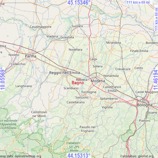
Bagno GPS coordinates[2]
44° 39' 19.62" North, 10° 45' 31.716" East
| Map corner | latitude | longitude |
|---|---|---|
| Upper-left | 45.15346°, | 10.05569° |
| Center: | 44.65545°, | 10.75881° |
| Lower-right: | 44.15313°, | 11.46194° |
| Map W x H: | 111.2×111.2 km | = 69.1×69.1mi |
| max Lat: | 47.04031° ⇑46.5% North |
| Bagno: | 44.65545° |
| min Lat: | ⇓53.5% South 35.50142° |
| min Long | Bagno | max Long |
| 6.69888° | 10.75881° | 18.48682° |
| W 39.8%⇐ | ⇒60.2% E |
Elevation
Elevation of Bagno is 52 m = 171 ft, and this is 254.7 m = 836 ft below average elevation for this country.
| Max E: |
2085 m = 6841 ft | 79.6% |
| Avg. | 306.7 m = 1006 ft | |
| Bagno | 52 m = 171 ft | |
Min E: |
-4 m = -13 ft | 20.4% |
See also: Italy elevation on elevation.city.
Geographical zone
Bagno is located in North temperate zone (between Tropic of Cancer and the Arctic Circle). Distance of this Northern Tropic circle is 2359.3 km =1466 mi to South.| Distance of | km | miles | from Bagno |
|---|---|---|---|
| North Pole | 5041.8 | 3132.8 | to North |
| Arctic Circle | 2436 | 1513.7 | to North |
| Tropic Cancer | 2359.3 | 1466 | to South |
| Equator | 4965.2 | 3085.2 | to South |


Nearby cities:
15 places around Bagno: (largest is in red/bold)
• Arceto
5 km =3.1 mi,  212°
212°
• Bosco
7.8 km =4.8 mi,  242°
242°
• Campogalliano
7.9 km =4.9 mi,  62°
62°
• Casalgrande
8.1 km =5 mi,  193°
193°
• Corticella
2.4 km =1.5 mi, 193°
• Fellegara
7 km =4.3 mi,  224°
224°
• Fontana
4.2 km =2.6 mi,  54°
54°
• Gavasseto
6.5 km =4 mi,  268°
268°
• Lemizzone
8.6 km =5.3 mi,  357°
357°
• Magreta
7 km =4.3 mi,  152°
152°
• Prato
6.8 km =4.2 mi,  352°
352°
• Rubiera
1.7 km =1.1 mi,  104°
104°
• Salvaterra
6.3 km =3.9 mi,  172°
172°
• San Faustino
3.3 km =2.1 mi,  31°
31°
• Scandiano
8.1 km =5 mi, 218°
Sources, notices
• [Note1] Compared only with cities in Italy existing in our database
• [Src1] Map data: © OpenStreetMap contributors (CC-BY-SA)
• [Src2] Other city data from geonames.org with taken over terms of usage.
• [Src3] Geographical zone / Annual Mean Temperature by Robert A. Rohde @ Wikipedia
