Casalgrande geodata
Casalgrande (Emilia-Romagna) is a seat of a third-order administrative division; located in Italy in Europe/Rome (GMT+2) time zone. With population of 7,451 people, there are 1306 cities with bigger population in this country. Compared to other cities in Italy, 52.2% of cities are located further ↓South; 60.6% of cities are located further →East and 68.1% of cities have higher elevation than Casalgrande. Note1
Administrative division(s):
- Level 1: Emilia-Romagna
- Level 2: Provincia di Reggio Emilia
- Level 3: Casalgrande


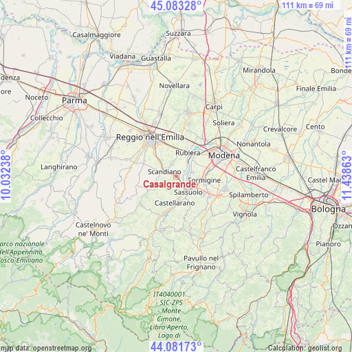
Casalgrande GPS coordinates[2]
44° 35' 4.776" North, 10° 44' 7.8" East
| Map corner | latitude | longitude |
|---|---|---|
| Upper-left | 45.08328°, | 10.03238° |
| Center: | 44.58466°, | 10.7355° |
| Lower-right: | 44.08173°, | 11.43863° |
| Map W x H: | 111.4×111.4 km | = 69.2×69.2mi |
| max Lat: | 47.04031° ⇑47.8% North |
| Casalgrande: | 44.58466° |
| min Lat: | ⇓52.2% South 35.50142° |
| min Long | Casalgrande | max Long |
| 6.69888° | 10.7355° | 18.48682° |
| W 39.4%⇐ | ⇒60.6% E |
Elevation
Elevation of Casalgrande is 108 m = 354 ft, and this is 198.7 m = 652 ft below average elevation for this country.
| Max E: |
2085 m = 6841 ft | 68.1% |
| Avg. | 306.7 m = 1006 ft | |
| Casalgrande | 108 m = 354 ft | |
Min E: |
-4 m = -13 ft | 31.9% |
See also: Italy elevation on elevation.city.
Geographical zone
Casalgrande is located in North temperate zone (between Tropic of Cancer and the Arctic Circle). Distance of this Northern Tropic circle is 2351.4 km =1461.1 mi to South.| Distance of | km | miles | from Casalgrande |
|---|---|---|---|
| North Pole | 5049.7 | 3137.7 | to North |
| Arctic Circle | 2443.8 | 1518.5 | to North |
| Tropic Cancer | 2351.4 | 1461.1 | to South |
| Equator | 4957.3 | 3080.3 | to South |


Nearby cities:
15 places around Casalgrande: (largest is in red/bold)
• Arceto
3.8 km =2.4 mi,  346°
346°
• Bosco
6.6 km =4.1 mi,  309°
309°
• Ca' de' Caroli
4.8 km =3 mi,  274°
274°
• Cadiroggio
4 km =2.5 mi,  171°
171°
• Castellarano
7.4 km =4.6 mi,  178°
178°
• Corticella
5.7 km =3.5 mi,  13°
13°
• Fellegara
4.2 km =2.6 mi, 313°
• Fiorano
7.9 km =4.9 mi,  130°
130°
• Magreta
5.4 km =3.4 mi,  71°
71°
• Pratissolo
5.3 km =3.3 mi,  294°
294°
• Salvaterra
3.1 km =1.9 mi,  58°
58°
• Sassuolo
6 km =3.7 mi,  139°
139°
• Scandiano
3.5 km =2.2 mi,  295°
295°
• Veggia-Villalunga
3.1 km =1.9 mi,  148°
148°
• Ventoso
3.8 km =2.4 mi, 272°
Sources, notices
• [Note1] Compared only with cities in Italy existing in our database
• [Src1] Map data: © OpenStreetMap contributors (CC-BY-SA)
• [Src2] Other city data from geonames.org with taken over terms of usage.
• [Src3] Geographical zone / Annual Mean Temperature by Robert A. Rohde @ Wikipedia
