Bondeno geodata
Bondeno (Lombardy) is a populated place; located in Italy in Europe/Rome (GMT+2) time zone. With population of 1,167 people, there are 6065 cities with bigger population in this country. Compared to other cities in Italy, 58.6% of cities are located further ↓South; 59% of cities are located further →East and 90.6% of cities have higher elevation than Bondeno. Note1


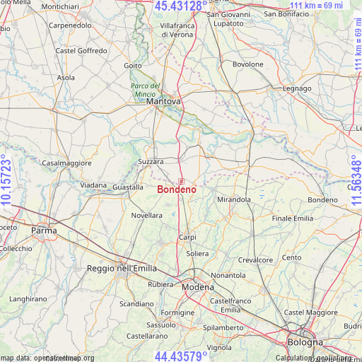
Bondeno GPS coordinates[2]
44° 56' 8.484" North, 10° 51' 37.26" East
| Map corner | latitude | longitude |
|---|---|---|
| Upper-left | 45.43128°, | 10.15723° |
| Center: | 44.93569°, | 10.86035° |
| Lower-right: | 44.43579°, | 11.56348° |
| Map W x H: | 110.7×110.7 km | = 68.8×68.8mi |
| max Lat: | 47.04031° ⇑41.4% North |
| Bondeno: | 44.93569° |
| min Lat: | ⇓58.6% South 35.50142° |
| min Long | Bondeno | max Long |
| 6.69888° | 10.86035° | 18.48682° |
| W 41%⇐ | ⇒59% E |
Elevation
Elevation of Bondeno is 17 m = 56 ft, and this is 289.7 m = 950 ft below average elevation for this country.
| Max E: |
2085 m = 6841 ft | 90.6% |
| Avg. | 306.7 m = 1006 ft | |
| Bondeno | 17 m = 56 ft | |
Min E: |
-4 m = -13 ft | 9.4% |
See also: Italy elevation on elevation.city.
Geographical zone
Bondeno is located in North temperate zone (between Tropic of Cancer and the Arctic Circle). Distance of this Northern Tropic circle is 2390.5 km =1485.4 mi to South.| Distance of | km | miles | from Bondeno |
|---|---|---|---|
| North Pole | 5010.7 | 3113.5 | to North |
| Arctic Circle | 2404.8 | 1494.3 | to North |
| Tropic Cancer | 2390.5 | 1485.4 | to South |
| Equator | 4996.4 | 3104.6 | to South |


Nearby cities:
15 places around Bondeno: (largest is in red/bold)
• Bondanello
7.2 km =4.5 mi,  68°
68°
• Brugneto
7.9 km =4.9 mi,  258°
258°
• Concordia sulla Secchia
10.4 km =6.5 mi,  104°
104°
• Fabbrico
8.1 km =5 mi,  209°
209°
• Gonzaga
3.7 km =2.3 mi,  299°
299°
• Moglia
4.3 km =2.7 mi,  90°
90°
• Novi di Modena
6 km =3.7 mi,  148°
148°
• Palidano
7.5 km =4.7 mi, 302°
• Pegognaga
6.5 km =4 mi,  359°
359°
• Polesine
7.1 km =4.4 mi,  321°
321°
• Reggiolo
4.4 km =2.7 mi,  243°
243°
• Rolo
5.7 km =3.5 mi,  180°
180°
• Suzzara
11.1 km =6.9 mi, 304°
• Villa Saviola
11.5 km =7.1 mi,  335°
335°
• Villarotta
9.2 km =5.7 mi, 262°
Sources, notices
• [Note1] Compared only with cities in Italy existing in our database
• [Src1] Map data: © OpenStreetMap contributors (CC-BY-SA)
• [Src2] Other city data from geonames.org with taken over terms of usage.
• [Src3] Geographical zone / Annual Mean Temperature by Robert A. Rohde @ Wikipedia
