Ferrara geodata
Ferrara (Emilia-Romagna) is a seat of a second-order administrative division; located in Italy in Europe/Rome (GMT+2) time zone. With population of 92,802 people, there are 42 cities with bigger population in this country. Compared to other cities in Italy, 56.9% of cities are located further ↓South; 50.9% of cities are located further ←West and 91.5% of cities have higher elevation than Ferrara. Note1


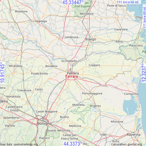
Ferrara GPS coordinates[2]
44° 50' 16.944" North, 11° 37' 14.052" East
| Map corner | latitude | longitude |
|---|---|---|
| Upper-left | 45.33447°, | 10.91745° |
| Center: | 44.83804°, | 11.62057° |
| Lower-right: | 44.3373°, | 12.3237° |
| Map W x H: | 110.9×110.9 km | = 68.9×68.9mi |
| max Lat: | 47.04031° ⇑43.1% North |
| Ferrara: | 44.83804° |
| min Lat: | ⇓56.9% South 35.50142° |
| min Long | Ferrara | max Long |
| 6.69888° | 11.62057° | 18.48682° |
| W 50.9%⇐ | ⇒49.1% E |
Elevation
Elevation of Ferrara is 15 m = 49 ft, and this is 291.7 m = 957 ft below average elevation for this country.
| Max E: |
2085 m = 6841 ft | 91.5% |
| Avg. | 306.7 m = 1006 ft | |
| Ferrara | 15 m = 49 ft | |
Min E: |
-4 m = -13 ft | 8.5% |
See also: Ferrara elevation on elevation.city.
Geographical zone
Ferrara is located in North temperate zone (between Tropic of Cancer and the Arctic Circle). Distance of this Northern Tropic circle is 2379.6 km =1478.6 mi to South.| Distance of | km | miles | from Ferrara |
|---|---|---|---|
| North Pole | 5021.5 | 3120.2 | to North |
| Arctic Circle | 2415.7 | 1501 | to North |
| Tropic Cancer | 2379.6 | 1478.6 | to South |
| Equator | 4985.5 | 3097.8 | to South |


Nearby cities:
15 places around Ferrara: (largest is in red/bold)
• Aguscello
4.7 km =2.9 mi,  138°
138°
• Baura
7.9 km =4.9 mi,  78°
78°
• Boara
5.8 km =3.6 mi,  60°
60°
• Casaglia
9.4 km =5.8 mi,  319°
319°
• Cona
7.7 km =4.8 mi,  117°
117°
• Coronella
8.6 km =5.3 mi,  242°
242°
• Fossanova San Marco
5.4 km =3.4 mi,  172°
172°
• Francolino
7.1 km =4.4 mi,  23°
23°
• Gaibanella-Sant'Edigio
8.3 km =5.2 mi,  163°
163°
• Occhiobello
9.9 km =6.2 mi,  341°
341°
• Pontegradella
3.3 km =2.1 mi,  89°
89°
• Porotto-Cassama
5.7 km =3.5 mi,  283°
283°
• San Martino
7.2 km =4.5 mi,  201°
201°
• Santa Maria Maddalena
7.2 km =4.5 mi,  351°
351°
• Vigarano Pieve
9.1 km =5.7 mi,  286°
286°
Sources, notices
• [Note1] Compared only with cities in Italy existing in our database
• [Src1] Map data: © OpenStreetMap contributors (CC-BY-SA)
• [Src2] Other city data from geonames.org with taken over terms of usage.
• [Src3] Geographical zone / Annual Mean Temperature by Robert A. Rohde @ Wikipedia
