Longhi geodata
Longhi (Veneto) is a seat of a third-order administrative division; located in Italy in Europe/Rome (GMT+2) time zone. With population of 211 people, there are 11077 cities with bigger population in this country. Compared to other cities in Italy, 89.4% of cities are located further ↓South; 53% of cities are located further →East and 74.2% of cities have lower elevation than Longhi. Note1


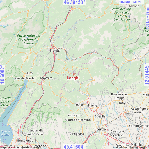
Longhi GPS coordinates[2]
45° 54' 26.784" North, 11° 18' 40.752" East
| Map corner | latitude | longitude |
|---|---|---|
| Upper-left | 46.39453°, | 10.6082° |
| Center: | 45.90744°, | 11.31132° |
| Lower-right: | 45.41604°, | 12.01445° |
| Map W x H: | 108.8×108.8 km | = 67.6×67.6mi |
| max Lat: | 47.04031° ⇑10.6% North |
| Longhi: | 45.90744° |
| min Lat: | ⇓89.4% South 35.50142° |
| min Long | Longhi | max Long |
| 6.69888° | 11.31132° | 18.48682° |
| W 47%⇐ | ⇒53% E |
Elevation
Elevation of Longhi is 442 m = 1450 ft, and this is 135.3 m = 444 ft above average elevation for this country.
| Max E: |
2085 m = 6841 ft | 25.8% |
| Longhi | 442 m 1450 ft | |
| Avg. | 306.7 m = 1006 ft | |
Min E: |
-4 m = -13 ft | 74.2% |
See also: Italy elevation on elevation.city.
Geographical zone
Longhi is located in North temperate zone (between Tropic of Cancer and the Arctic Circle). Distance of this North polar circle is 2296.7 km =1427.1 mi to North.| Distance of | km | miles | from Longhi |
|---|---|---|---|
| North Pole | 4902.6 | 3046.3 | to North |
| Arctic Circle | 2296.7 | 1427.1 | to North |
| Tropic Cancer | 2498.5 | 1552.5 | to South |
| Equator | 5104.4 | 3171.7 | to South |


Nearby cities:
15 places around Longhi: (largest is in red/bold)
• Barco
10.9 km =6.8 mi,  11°
11°
• Caldonazzo
10.3 km =6.4 mi,  339°
339°
• Centa San Nicolò
9.2 km =5.7 mi,  318°
318°
• Folgaria
11.1 km =6.9 mi,  274°
274°
• Gionghi-Cappella
4.3 km =2.7 mi, 319°
• Laghi
9.7 km =6 mi,  198°
198°
• Lastebasse
3 km =1.9 mi,  286°
286°
• Levico Terme
11.7 km =7.3 mi,  357°
357°
• Luserna
1.9 km =1.2 mi,  27°
27°
• Pedemonte
0.2 km =0.1 mi,  296°
296°
• Roana
11.5 km =7.1 mi,  107°
107°
• Rotzo
8.3 km =5.2 mi,  127°
127°
• San Pietro Valdastico
4.5 km =2.8 mi,  120°
120°
• Tonezza del Cimone
6 km =3.7 mi,  153°
153°
• Treschè Conca
11.9 km =7.4 mi, 130°
Sources, notices
• [Note1] Compared only with cities in Italy existing in our database
• [Src1] Map data: © OpenStreetMap contributors (CC-BY-SA)
• [Src2] Other city data from geonames.org with taken over terms of usage.
• [Src3] Geographical zone / Annual Mean Temperature by Robert A. Rohde @ Wikipedia
