bishopric of Perugia geodata
bishopric of Perugia (Umbria) is a seat of government of a political entity; located in Italy in Europe/Rome (GMT+2) time zone. In our database, there are 11707 cities with bigger population. Compared to other cities in Italy, 62.5% of cities are located further ↑North; 61.2% of cities are located further ←West and 70% of cities have lower elevation than bishopric of Perugia. Note1
Current local time in bishopric of Perugia:
05:28 PM, WednesdayDifference from your time zone: hours


bishopric of Perugia GPS coordinates[2]
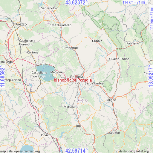
43° 6' 45.288" North, 12° 23' 20.544" East
| Map corner | latitude | longitude |
|---|---|---|
| Upper-left | 43.62372°, | 11.68592° |
| Center: | 43.11258°, | 12.38904° |
| Lower-right: | 42.59714°, | 13.09217° |
| Map W x H: | 114.1×114.1 km | = 70.9×70.9mi |
| max Lat: | 47.04031° ⇑62.5% North |
| bishopric of Perugia: | 43.11258° |
| min Lat: | ⇓37.5% South 35.50142° |
| min Long | bishopric of Pe | max Long |
| 6.69888° | 12.38904° | 18.48682° |
| W 61.2%⇐ | ⇒38.8% E |
Elevation
Elevation of bishopric of Perugia is 395 m = 1296 ft, and this is 88.3 m = 290 ft above average elevation for this country.
| Max E: |
2085 m = 6841 ft | 30% |
| bishopric of Perugia | 395 m 1296 ft | |
| Avg. | 306.7 m = 1006 ft | |
Min E: |
-4 m = -13 ft | 70% |
See also: Italy elevation on elevation.city.
Geographical zone
bishopric of Perugia is located in North temperate zone (between Tropic of Cancer and the Arctic Circle). Distance of this Northern Tropic circle is 2187.8 km =1359.4 mi to South.| Distance of | km | miles | from bishopric of Perugia |
|---|---|---|---|
| North Pole | 5213.4 | 3239.5 | to North |
| Arctic Circle | 2607.5 | 1620.2 | to North |
| Tropic Cancer | 2187.8 | 1359.4 | to South |
| Equator | 4793.7 | 2978.7 | to South |


Nearby cities:
15 places around bishopric of Perugia: (largest is in red/bold)
• Chiugiana-La Commenda
6.8 km =4.2 mi,  256°
256°
• Comparati
7.4 km =4.6 mi,  315°
315°
• Corciano
8.5 km =5.3 mi,  281°
281°
• Il Rigo
7.3 km =4.5 mi, 262°
• Lacugnano
5.1 km =3.2 mi,  247°
247°
• Oliveto
2 km =1.2 mi,  306°
306°
• Oscano
6.6 km =4.1 mi, 320°
• Osteria di Ramazzano
8.8 km =5.5 mi,  42°
42°
• Perugia
0 km =0 mi,  206°
206°
• Pila
8.2 km =5.1 mi,  216°
216°
• Ponte Felcino
5.3 km =3.3 mi,  67°
67°
• Ponte Pattoli
8 km =5 mi,  23°
23°
• San Martino in Campo
8.6 km =5.3 mi,  172°
172°
• Sant'Egidio
8.3 km =5.2 mi,  97°
97°
• Via Lippia
8 km =5 mi,  111°
111°
Sources, notices
• [Note1] Compared only with cities in Italy existing in our database
• [Src1] Map data: © OpenStreetMap contributors (CC-BY-SA)
• [Src2] Other city data from geonames.org with taken over terms of usage.
• [Src3] Geographical zone / Annual Mean Temperature by Robert A. Rohde @ Wikipedia
