Lacugnano geodata
Lacugnano (Umbria) is a populated place; located in Italy in Europe/Rome (GMT+2) time zone. With population of 1,202 people, there are 5951 cities with bigger population in this country. Compared to other cities in Italy, 62.6% of cities are located further ↑North; 60.4% of cities are located further ←West and 62.8% of cities have lower elevation than Lacugnano. Note1


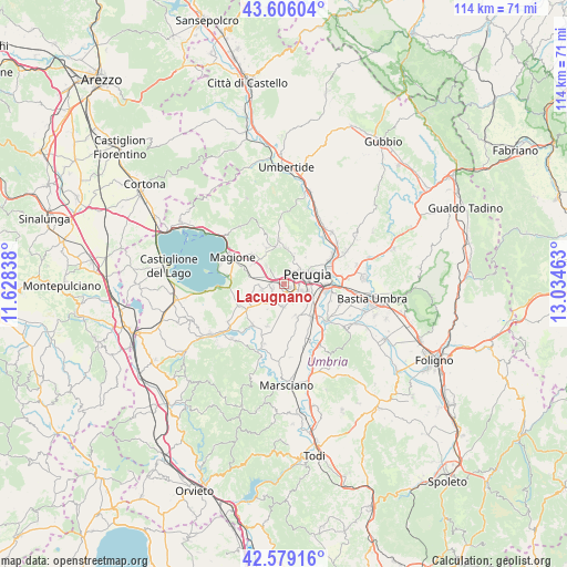
Lacugnano GPS coordinates[2]
43° 5' 41.1" North, 12° 19' 53.4" East
| Map corner | latitude | longitude |
|---|---|---|
| Upper-left | 43.60604°, | 11.62838° |
| Center: | 43.09475°, | 12.3315° |
| Lower-right: | 42.57916°, | 13.03463° |
| Map W x H: | 114.2×114.2 km | = 71×71mi |
| max Lat: | 47.04031° ⇑62.6% North |
| Lacugnano: | 43.09475° |
| min Lat: | ⇓37.4% South 35.50142° |
| min Long | Lacugnano | max Long |
| 6.69888° | 12.3315° | 18.48682° |
| W 60.4%⇐ | ⇒39.6% E |
Elevation
Elevation of Lacugnano is 322 m = 1056 ft, and this is 15.3 m = 50 ft above average elevation for this country.
| Max E: |
2085 m = 6841 ft | 37.2% |
| Lacugnano | 322 m 1056 ft | |
| Avg. | 306.7 m = 1006 ft | |
Min E: |
-4 m = -13 ft | 62.8% |
See also: Italy elevation on elevation.city.
Geographical zone
Lacugnano is located in North temperate zone (between Tropic of Cancer and the Arctic Circle). Distance of this Northern Tropic circle is 2185.8 km =1358.2 mi to South.| Distance of | km | miles | from Lacugnano |
|---|---|---|---|
| North Pole | 5215.4 | 3240.7 | to North |
| Arctic Circle | 2609.5 | 1621.5 | to North |
| Tropic Cancer | 2185.8 | 1358.2 | to South |
| Equator | 4791.7 | 2977.4 | to South |


Nearby cities:
15 places around Lacugnano: (largest is in red/bold)
• Agello
8 km =5 mi,  250°
250°
• Chiugiana-La Commenda
1.9 km =1.2 mi,  281°
281°
• Comparati
7.2 km =4.5 mi,  355°
355°
• Corciano
5.2 km =3.2 mi,  315°
315°
• Il Rigo
2.8 km =1.7 mi,  291°
291°
• Mantignana
8 km =5 mi,  334°
334°
• Oliveto
4.4 km =2.7 mi,  43°
43°
• Oscano
7.1 km =4.4 mi,  4°
4°
• Perugia
5 km =3.1 mi,  67°
67°
• Pila
4.6 km =2.9 mi,  182°
182°
• San Biagio della Valle
9 km =5.6 mi,  203°
203°
• San Martino in Campo
8.7 km =5.4 mi,  138°
138°
• San Pietro
5.1 km =3.2 mi,  301°
301°
• Soccorso
9.1 km =5.7 mi, 303°
• bishopric of Perugia
5.1 km =3.2 mi, 67°
Sources, notices
• [Note1] Compared only with cities in Italy existing in our database
• [Src1] Map data: © OpenStreetMap contributors (CC-BY-SA)
• [Src2] Other city data from geonames.org with taken over terms of usage.
• [Src3] Geographical zone / Annual Mean Temperature by Robert A. Rohde @ Wikipedia
