Corciano geodata
Corciano (Umbria) is a seat of a third-order administrative division; located in Italy in Europe/Rome (GMT+2) time zone. With population of 806 people, there are 7616 cities with bigger population in this country. Compared to other cities in Italy, 62.4% of cities are located further ↑North; 59.7% of cities are located further ←West and 70% of cities have lower elevation than Corciano. Note1


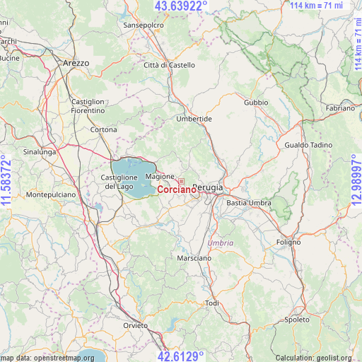
Corciano GPS coordinates[2]
43° 7' 41.556" North, 12° 17' 12.624" East
| Map corner | latitude | longitude |
|---|---|---|
| Upper-left | 43.63922°, | 11.58372° |
| Center: | 43.12821°, | 12.28684° |
| Lower-right: | 42.6129°, | 12.98997° |
| Map W x H: | 114.1×114.1 km | = 70.9×70.9mi |
| max Lat: | 47.04031° ⇑62.4% North |
| Corciano: | 43.12821° |
| min Lat: | ⇓37.6% South 35.50142° |
| min Long | Corciano | max Long |
| 6.69888° | 12.28684° | 18.48682° |
| W 59.7%⇐ | ⇒40.3% E |
Elevation
Elevation of Corciano is 395 m = 1296 ft, and this is 88.3 m = 290 ft above average elevation for this country.
| Max E: |
2085 m = 6841 ft | 30% |
| Corciano | 395 m 1296 ft | |
| Avg. | 306.7 m = 1006 ft | |
Min E: |
-4 m = -13 ft | 70% |
See also: Italy elevation on elevation.city.
Geographical zone
Corciano is located in North temperate zone (between Tropic of Cancer and the Arctic Circle). Distance of this Northern Tropic circle is 2189.5 km =1360.5 mi to South.| Distance of | km | miles | from Corciano |
|---|---|---|---|
| North Pole | 5211.7 | 3238.4 | to North |
| Arctic Circle | 2605.8 | 1619.2 | to North |
| Tropic Cancer | 2189.5 | 1360.5 | to South |
| Equator | 4795.4 | 2979.7 | to South |


Nearby cities:
15 places around Corciano: (largest is in red/bold)
• Agello
7.5 km =4.7 mi,  211°
211°
• Chiugiana-La Commenda
3.8 km =2.4 mi,  152°
152°
• Comparati
4.6 km =2.9 mi,  41°
41°
• Il Rigo
2.9 km =1.8 mi,  158°
158°
• Lacugnano
5.2 km =3.2 mi,  135°
135°
• Magione
6.3 km =3.9 mi,  283°
283°
• Mantignana
3.5 km =2.2 mi,  2°
2°
• Oliveto
6.7 km =4.2 mi,  94°
94°
• Oscano
5.3 km =3.3 mi,  50°
50°
• Perugia
8.5 km =5.3 mi,  102°
102°
• Pila
9 km =5.6 mi, 157°
• San Pietro
1.2 km =0.7 mi, 212°
• San Savino
7.9 km =4.9 mi,  253°
253°
• Soccorso
4.2 km =2.6 mi,  287°
287°
• bishopric of Perugia
8.5 km =5.3 mi, 101°
Sources, notices
• [Note1] Compared only with cities in Italy existing in our database
• [Src1] Map data: © OpenStreetMap contributors (CC-BY-SA)
• [Src2] Other city data from geonames.org with taken over terms of usage.
• [Src3] Geographical zone / Annual Mean Temperature by Robert A. Rohde @ Wikipedia
