Oliveto geodata
Oliveto (Umbria) is a populated place; located in Italy in Europe/Rome (GMT+2) time zone. With population of 1,000 people, there are 6662 cities with bigger population in this country. Compared to other cities in Italy, 62.4% of cities are located further ↑North; 60.9% of cities are located further ←West and 70.8% of cities have lower elevation than Oliveto. Note1


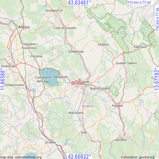
Oliveto GPS coordinates[2]
43° 7' 24.852" North, 12° 22' 7.68" East
| Map corner | latitude | longitude |
|---|---|---|
| Upper-left | 43.63461°, | 11.66568° |
| Center: | 43.12357°, | 12.3688° |
| Lower-right: | 42.60822°, | 13.07193° |
| Map W x H: | 114.1×114.1 km | = 70.9×70.9mi |
| max Lat: | 47.04031° ⇑62.4% North |
| Oliveto: | 43.12357° |
| min Lat: | ⇓37.6% South 35.50142° |
| min Long | Oliveto | max Long |
| 6.69888° | 12.3688° | 18.48682° |
| W 60.9%⇐ | ⇒39.1% E |
Elevation
Elevation of Oliveto is 401 m = 1316 ft, and this is 94.3 m = 309 ft above average elevation for this country.
| Max E: |
2085 m = 6841 ft | 29.2% |
| Oliveto | 401 m 1316 ft | |
| Avg. | 306.7 m = 1006 ft | |
Min E: |
-4 m = -13 ft | 70.8% |
See also: Italy elevation on elevation.city.
Geographical zone
Oliveto is located in North temperate zone (between Tropic of Cancer and the Arctic Circle). Distance of this Northern Tropic circle is 2189 km =1360.2 mi to South.| Distance of | km | miles | from Oliveto |
|---|---|---|---|
| North Pole | 5212.2 | 3238.7 | to North |
| Arctic Circle | 2606.3 | 1619.5 | to North |
| Tropic Cancer | 2189 | 1360.2 | to South |
| Equator | 4794.9 | 2979.4 | to South |


Nearby cities:
15 places around Oliveto: (largest is in red/bold)
• Casa del Diavolo
9.7 km =6 mi,  42°
42°
• Chiugiana-La Commenda
5.7 km =3.5 mi,  240°
240°
• Comparati
5.4 km =3.4 mi,  318°
318°
• Corciano
6.7 km =4.2 mi,  274°
274°
• Il Rigo
6 km =3.7 mi,  248°
248°
• Lacugnano
4.4 km =2.7 mi,  223°
223°
• Mantignana
7.7 km =4.8 mi,  301°
301°
• Oscano
4.6 km =2.9 mi,  327°
327°
• Osteria di Ramazzano
9.2 km =5.7 mi,  54°
54°
• Perugia
2.1 km =1.3 mi,  127°
127°
• Pila
8.5 km =5.3 mi,  202°
202°
• Ponte Felcino
6.6 km =4.1 mi,  83°
83°
• Ponte Pattoli
7.8 km =4.8 mi, 38°
• San Pietro
7.3 km =4.5 mi, 265°
• bishopric of Perugia
2 km =1.2 mi, 126°
Sources, notices
• [Note1] Compared only with cities in Italy existing in our database
• [Src1] Map data: © OpenStreetMap contributors (CC-BY-SA)
• [Src2] Other city data from geonames.org with taken over terms of usage.
• [Src3] Geographical zone / Annual Mean Temperature by Robert A. Rohde @ Wikipedia
