Bog Walk geodata
Bog Walk (Saint Catherine) is a populated place; located in Jamaica in America/Jamaica (GMT-5) time zone. With population of 12,873 people, there are 13 cities with bigger population in this country. Compared to other cities in Jamaica, 53.8% of cities are located further ↑North; 67% of cities are located further ←West and 56% of cities have higher elevation than Bog Walk. Note1


Bog Walk GPS coordinates[2]
18° 6' 7.38" North, 77° 0' 19.476" West
| Map corner | latitude | longitude |
|---|---|---|
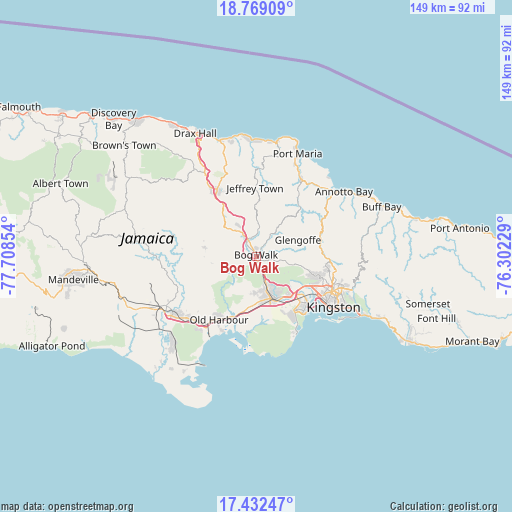
| Upper-left | 18.76909°, | -77.70854° |
| Center: | 18.10205°, | -77.00541° |
| Lower-right: | 17.43247°, | -76.30229° |
| Map W x H: | 148.6×148.6 km | = 92.3×92.3mi |
| max Lat: | 18.49358° ⇑53.8% North |
| Bog Walk: | 18.10205° |
| min Lat: | ⇓46.2% South 17.774° |
| min Long | Bog Walk | max Long |
| -78.3481° | -77.00541° | -76.24864° |
| W 67%⇐ | ⇒33% E |
Elevation
Elevation of Bog Walk is 86 m = 282 ft, and this is 128.4 m = 421 ft below average elevation for this country.
| Max E: |
944 m = 3097 ft | 56% |
| Avg. | 214.4 m = 703 ft | |
| Bog Walk | 86 m = 282 ft | |
Min E: |
1 m = 3 ft | 44% |
See also: Jamaica elevation on elevation.city.
Geographical zone
Bog Walk is located in North Torrid zone (between Equator and Tropic of Cancer). Distance of this Northern Tropic circle is 593.2 km =368.6 mi to North.| Distance of | km | miles | from Bog Walk |
|---|---|---|---|
| North Pole | 7994.3 | 4967.4 | to North |
| Arctic Circle | 5388.4 | 3348.2 | to North |
| Tropic Cancer | 593.2 | 368.6 | to North |
| Equator | 2012.8 | 1250.7 | to South |


Nearby cities:
15 places around Bog Walk: (largest is in red/bold)
• Constant Spring
23.1 km =14.4 mi,  104°
104°
• Ewarton
12.4 km =7.7 mi,  316°
316°
• Half Way Tree
24 km =14.9 mi,  114°
114°
• Linstead
4.8 km =3 mi, 324°
• Lluidas Vale
15.3 km =9.5 mi,  279°
279°
• Lucky Hill
23.2 km =14.4 mi,  358°
358°
• Moneague
22.3 km =13.9 mi,  329°
329°
• Old Harbour
20.9 km =13 mi,  211°
211°
• Old Harbour Bay
23.5 km =14.6 mi,  204°
204°
• Point Hill
10.9 km =6.8 mi,  262°
262°
• Portmore
21.3 km =13.2 mi,  142°
142°
• Richmond
21 km =13 mi,  36°
36°
• Riversdale
8.3 km =5.2 mi,  31°
31°
• Spanish Town
13.3 km =8.3 mi,  157°
157°
• Stony Hill
23.5 km =14.6 mi, 96°
Sources, notices
• [Note1] Compared only with cities in Jamaica existing in our database
• [Src1] Map data: © OpenStreetMap contributors (CC-BY-SA)
• [Src2] Other city data from geonames.org with taken over terms of usage.
• [Src3] Geographical zone / Annual Mean Temperature by Robert A. Rohde @ Wikipedia
