Linstead geodata
Linstead (Saint Catherine) is a populated place; located in Jamaica in America/Jamaica (GMT-5) time zone. With population of 20,660 people, there are 8 cities with bigger population in this country. Compared to other cities in Jamaica, 51.6% of cities are located further ↑North; 63.7% of cities are located further ←West and 51.6% of cities have lower elevation than Linstead. Note1


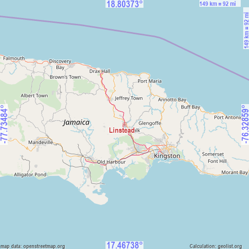
Linstead GPS coordinates[2]
18° 8' 12.588" North, 77° 1' 54.156" West
| Map corner | latitude | longitude |
|---|---|---|
| Upper-left | 18.80373°, | -77.73484° |
| Center: | 18.13683°, | -77.03171° |
| Lower-right: | 17.46738°, | -76.32859° |
| Map W x H: | 148.6×148.6 km | = 92.3×92.3mi |
| max Lat: | 18.49358° ⇑51.6% North |
| Linstead: | 18.13683° |
| min Lat: | ⇓48.4% South 17.774° |
| min Long | Linstead | max Long |
| -78.3481° | -77.03171° | -76.24864° |
| W 63.7%⇐ | ⇒36.3% E |
Elevation
Elevation of Linstead is 119 m = 390 ft, and this is 95.4 m = 313 ft below average elevation for this country.
| Max E: |
944 m = 3097 ft | 48.4% |
| Avg. | 214.4 m = 703 ft | |
| Linstead | 119 m = 390 ft | |
Min E: |
1 m = 3 ft | 51.6% |
See also: Jamaica elevation on elevation.city.
Geographical zone
Linstead is located in North Torrid zone (between Equator and Tropic of Cancer). Distance of this Northern Tropic circle is 589.3 km =366.2 mi to North.| Distance of | km | miles | from Linstead |
|---|---|---|---|
| North Pole | 7990.4 | 4965 | to North |
| Arctic Circle | 5384.5 | 3345.8 | to North |
| Tropic Cancer | 589.3 | 366.2 | to North |
| Equator | 2016.6 | 1253.1 | to South |


Nearby cities:
15 places around Linstead: (largest is in red/bold)
• Bog Walk
4.8 km =3 mi,  144°
144°
• Chapelton
25.5 km =15.8 mi,  256°
256°
• Ewarton
7.7 km =4.8 mi,  312°
312°
• Gayle
21.2 km =13.2 mi,  6°
6°
• Kellits
25.4 km =15.8 mi,  276°
276°
• Lluidas Vale
12.4 km =7.7 mi, 264°
• Lucky Hill
19.4 km =12.1 mi, 6°
• Moneague
17.6 km =10.9 mi,  331°
331°
• Old Harbour
23.2 km =14.4 mi,  200°
200°
• Old Harbour Bay
26.2 km =16.3 mi, 195°
• Point Hill
9.6 km =6 mi,  236°
236°
• Portmore
26.1 km =16.2 mi, 142°
• Richmond
20.1 km =12.5 mi,  49°
49°
• Riversdale
7.8 km =4.8 mi,  65°
65°
• Spanish Town
18 km =11.2 mi,  154°
154°
Sources, notices
• [Note1] Compared only with cities in Jamaica existing in our database
• [Src1] Map data: © OpenStreetMap contributors (CC-BY-SA)
• [Src2] Other city data from geonames.org with taken over terms of usage.
• [Src3] Geographical zone / Annual Mean Temperature by Robert A. Rohde @ Wikipedia
