Richmond geodata
Richmond (St. Mary) is a populated place; located in Jamaica in America/Jamaica (GMT-5) time zone. With population of 2,046 people, there are 74 cities with bigger population in this country. Compared to other cities in Jamaica, 64.8% of cities are located further ↓South; 72.5% of cities are located further ←West and 60.4% of cities have lower elevation than Richmond. Note1


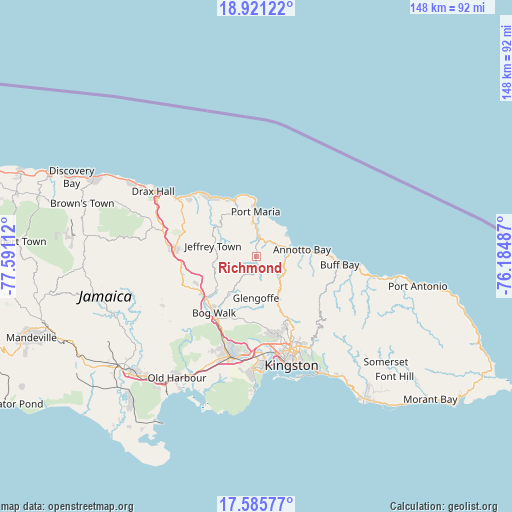
Richmond GPS coordinates[2]
18° 15' 17.208" North, 76° 53' 16.764" West
| Map corner | latitude | longitude |
|---|---|---|
| Upper-left | 18.92122°, | -77.59112° |
| Center: | 18.25478°, | -76.88799° |
| Lower-right: | 17.58577°, | -76.18487° |
| Map W x H: | 148.5×148.5 km | = 92.3×92.3mi |
| max Lat: | 18.49358° ⇑35.2% North |
| Richmond: | 18.25478° |
| min Lat: | ⇓64.8% South 17.774° |
| min Long | Richmond | max Long |
| -78.3481° | -76.88799° | -76.24864° |
| W 72.5%⇐ | ⇒27.5% E |
Elevation
Elevation of Richmond is 191 m = 627 ft, and this is 23.4 m = 77 ft below average elevation for this country.
| Max E: |
944 m = 3097 ft | 39.6% |
| Avg. | 214.4 m = 703 ft | |
| Richmond | 191 m = 627 ft | |
Min E: |
1 m = 3 ft | 60.4% |
See also: Jamaica elevation on elevation.city.
Geographical zone
Richmond is located in North Torrid zone (between Equator and Tropic of Cancer). Distance of this Northern Tropic circle is 576.2 km =358 mi to North.| Distance of | km | miles | from Richmond |
|---|---|---|---|
| North Pole | 7977.3 | 4956.9 | to North |
| Arctic Circle | 5371.4 | 3337.6 | to North |
| Tropic Cancer | 576.2 | 358 | to North |
| Equator | 2029.7 | 1261.2 | to South |


Nearby cities:
15 places around Richmond: (largest is in red/bold)
• Annotto Bay
13.1 km =8.1 mi,  81°
81°
• Bog Walk
21 km =13 mi,  216°
216°
• Buff Bay
24.1 km =15 mi,  95°
95°
• Constant Spring
24.8 km =15.4 mi,  156°
156°
• Ewarton
22.3 km =13.9 mi,  249°
249°
• Gayle
15.1 km =9.4 mi,  301°
301°
• Islington
7 km =4.3 mi,  30°
30°
• Linstead
20.1 km =12.5 mi,  229°
229°
• Lucky Hill
14.3 km =8.9 mi, 295°
• Moneague
23.7 km =14.7 mi,  275°
275°
• Ocho Rios
28.4 km =17.6 mi,  306°
306°
• Oracabessa
17.6 km =10.9 mi,  339°
339°
• Port Maria
12.6 km =7.8 mi,  359°
359°
• Riversdale
12.7 km =7.9 mi, 219°
• Stony Hill
22.4 km =13.9 mi,  150°
150°
Sources, notices
• [Note1] Compared only with cities in Jamaica existing in our database
• [Src1] Map data: © OpenStreetMap contributors (CC-BY-SA)
• [Src2] Other city data from geonames.org with taken over terms of usage.
• [Src3] Geographical zone / Annual Mean Temperature by Robert A. Rohde @ Wikipedia
