Black River geodata
Black River (St. Elizabeth) is a seat of a first-order administrative division; located in Jamaica in America/Jamaica (GMT-5) time zone. With population of 4,229 people, there are 36 cities with bigger population in this country. Compared to other cities in Jamaica, 70.3% of cities are located further ↑North; 84.6% of cities are located further →East and 96.7% of cities have higher elevation than Black River. Note1


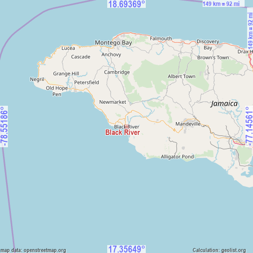
Black River GPS coordinates[2]
18° 1' 34.896" North, 77° 50' 55.428" West
| Map corner | latitude | longitude |
|---|---|---|
| Upper-left | 18.69369°, | -78.55186° |
| Center: | 18.02636°, | -77.84873° |
| Lower-right: | 17.35649°, | -77.14561° |
| Map W x H: | 148.7×148.7 km | = 92.4×92.4mi |
| max Lat: | 18.49358° ⇑70.3% North |
| Black River: | 18.02636° |
| min Lat: | ⇓29.7% South 17.774° |
| min Long | Black River | max Long |
| -78.3481° | -77.84873° | -76.24864° |
| W 15.4%⇐ | ⇒84.6% E |
Elevation
Elevation of Black River is 5 m = 16 ft, and this is 209.4 m = 687 ft below average elevation for this country.
| Max E: |
944 m = 3097 ft | 96.7% |
| Avg. | 214.4 m = 703 ft | |
| Black River | 5 m = 16 ft | |
Min E: |
1 m = 3 ft | 3.3% |
See also: Jamaica elevation on elevation.city.
Geographical zone
Black River is located in North Torrid zone (between Equator and Tropic of Cancer). Distance of this Northern Tropic circle is 601.6 km =373.8 mi to North.| Distance of | km | miles | from Black River |
|---|---|---|---|
| North Pole | 8002.7 | 4972.6 | to North |
| Arctic Circle | 5396.8 | 3353.4 | to North |
| Tropic Cancer | 601.6 | 373.8 | to North |
| Equator | 2004.3 | 1245.4 | to South |


Nearby cities:
15 places around Black River: (largest is in red/bold)
• Alligator Pond
34.5 km =21.4 mi,  120°
120°
• Balaclava
27.1 km =16.8 mi,  53°
53°
• Bethel Town
31.8 km =19.8 mi,  340°
340°
• Bluefields
24.4 km =15.2 mi,  309°
309°
• Bull Savanna
31.4 km =19.5 mi, 119°
• Cambridge
32.4 km =20.1 mi,  349°
349°
• Darliston
27.1 km =16.8 mi,  330°
330°
• Lacovia
11.6 km =7.2 mi,  63°
63°
• Maggotty
17.4 km =10.8 mi,  31°
31°
• Malvern
17.1 km =10.6 mi,  112°
112°
• Nain
26.6 km =16.5 mi,  104°
104°
• Quickstep
33.9 km =21.1 mi,  39°
39°
• Santa Cruz
16.2 km =10.1 mi,  79°
79°
• Siloah
21.9 km =13.6 mi, 44°
• Southfield
24.6 km =15.3 mi,  128°
128°
Sources, notices
• [Note1] Compared only with cities in Jamaica existing in our database
• [Src1] Map data: © OpenStreetMap contributors (CC-BY-SA)
• [Src2] Other city data from geonames.org with taken over terms of usage.
• [Src3] Geographical zone / Annual Mean Temperature by Robert A. Rohde @ Wikipedia
