Alligator Pond geodata
Alligator Pond (St. Elizabeth) is a populated place; located in Jamaica in America/Jamaica (GMT-5) time zone. With population of 1,793 people, there are 78 cities with bigger population in this country. Compared to other cities in Jamaica, 96.7% of cities are located further ↑North; 69.2% of cities are located further →East and 70.3% of cities have higher elevation than Alligator Pond. Note1


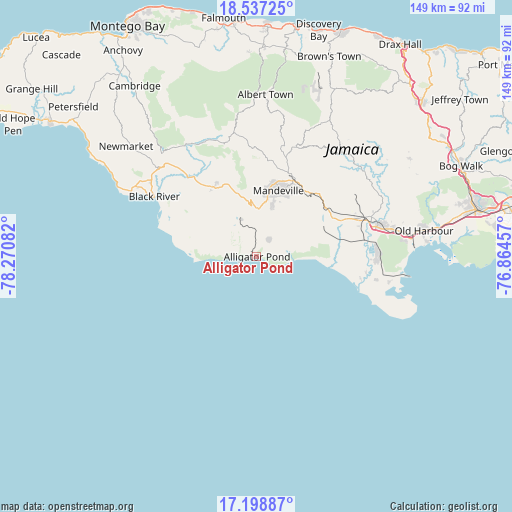
Alligator Pond GPS coordinates[2]
17° 52' 9.552" North, 77° 34' 3.684" West
| Map corner | latitude | longitude |
|---|---|---|
| Upper-left | 18.53725°, | -78.27082° |
| Center: | 17.86932°, | -77.56769° |
| Lower-right: | 17.19887°, | -76.86457° |
| Map W x H: | 148.8×148.8 km | = 92.5×92.5mi |
| max Lat: | 18.49358° ⇑96.7% North |
| Alligator Pond: | 17.86932° |
| min Lat: | ⇓3.3% South 17.774° |
| min Long | Alligator Pond | max Long |
| -78.3481° | -77.56769° | -76.24864° |
| W 30.8%⇐ | ⇒69.2% E |
Elevation
Elevation of Alligator Pond is 38 m = 125 ft, and this is 176.4 m = 579 ft below average elevation for this country.
| Max E: |
944 m = 3097 ft | 70.3% |
| Avg. | 214.4 m = 703 ft | |
| Alligator Pond | 38 m = 125 ft | |
Min E: |
1 m = 3 ft | 29.7% |
See also: Jamaica elevation on elevation.city.
Geographical zone
Alligator Pond is located in North Torrid zone (between Equator and Tropic of Cancer). Distance of this Northern Tropic circle is 619 km =384.6 mi to North.| Distance of | km | miles | from Alligator Pond |
|---|---|---|---|
| North Pole | 8020.2 | 4983.5 | to North |
| Arctic Circle | 5414.3 | 3364.3 | to North |
| Tropic Cancer | 619 | 384.6 | to North |
| Equator | 1986.9 | 1234.6 | to South |


Nearby cities:
15 places around Alligator Pond: (largest is in red/bold)
• Balaclava
34.6 km =21.5 mi,  346°
346°
• Black River
34.5 km =21.4 mi,  300°
300°
• Bull Savanna
3.1 km =1.9 mi,  309°
309°
• Lacovia
29.7 km =18.5 mi,  319°
319°
• Limit
33.1 km =20.6 mi,  17°
17°
• Malvern
17.7 km =11 mi, 307°
• Mandeville
20.2 km =12.6 mi, 18°
• Mocho
31.5 km =19.6 mi,  52°
52°
• Nain
11.4 km =7.1 mi,  339°
339°
• Porus
24.8 km =15.4 mi,  41°
41°
• Race Course
30.4 km =18.9 mi,  96°
96°
• Rocky Point
34.1 km =21.2 mi,  108°
108°
• Santa Cruz
24.7 km =15.3 mi,  325°
325°
• Southfield
10.7 km =6.6 mi,  281°
281°
• Williamsfield
24.4 km =15.2 mi,  25°
25°
Sources, notices
• [Note1] Compared only with cities in Jamaica existing in our database
• [Src1] Map data: © OpenStreetMap contributors (CC-BY-SA)
• [Src2] Other city data from geonames.org with taken over terms of usage.
• [Src3] Geographical zone / Annual Mean Temperature by Robert A. Rohde @ Wikipedia
