Nain geodata
Nain (St. Elizabeth) is a populated place; located in Jamaica in America/Jamaica (GMT-5) time zone. With population of 2,394 people, there are 69 cities with bigger population in this country. Compared to other cities in Jamaica, 78% of cities are located further ↑North; 71.4% of cities are located further →East and 62.6% of cities have lower elevation than Nain. Note1


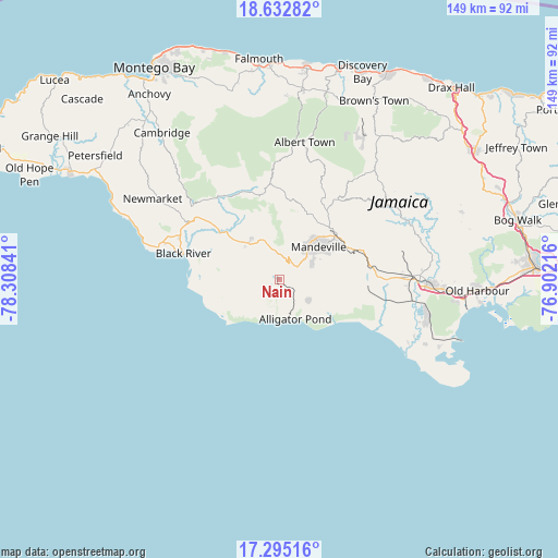
Nain GPS coordinates[2]
17° 57' 54.936" North, 77° 36' 19.008" West
| Map corner | latitude | longitude |
|---|---|---|
| Upper-left | 18.63282°, | -78.30841° |
| Center: | 17.96526°, | -77.60528° |
| Lower-right: | 17.29516°, | -76.90216° |
| Map W x H: | 148.7×148.7 km | = 92.4×92.4mi |
| max Lat: | 18.49358° ⇑78% North |
| Nain: | 17.96526° |
| min Lat: | ⇓22% South 17.774° |
| min Long | Nain | max Long |
| -78.3481° | -77.60528° | -76.24864° |
| W 28.6%⇐ | ⇒71.4% E |
Elevation
Elevation of Nain is 192 m = 630 ft, and this is 22.4 m = 73 ft below average elevation for this country.
| Max E: |
944 m = 3097 ft | 37.4% |
| Avg. | 214.4 m = 703 ft | |
| Nain | 192 m = 630 ft | |
Min E: |
1 m = 3 ft | 62.6% |
See also: Jamaica elevation on elevation.city.
Geographical zone
Nain is located in North Torrid zone (between Equator and Tropic of Cancer). Distance of this Northern Tropic circle is 608.4 km =378 mi to North.| Distance of | km | miles | from Nain |
|---|---|---|---|
| North Pole | 8009.5 | 4976.9 | to North |
| Arctic Circle | 5403.6 | 3357.6 | to North |
| Tropic Cancer | 608.4 | 378 | to North |
| Equator | 1997.5 | 1241.2 | to South |


Nearby cities:
15 places around Nain: (largest is in red/bold)
• Alligator Pond
11.4 km =7.1 mi,  159°
159°
• Balaclava
23.4 km =14.5 mi,  349°
349°
• Black River
26.6 km =16.5 mi,  284°
284°
• Bull Savanna
8.9 km =5.5 mi,  169°
169°
• Coleyville
28.9 km =18 mi,  20°
20°
• Lacovia
19.4 km =12.1 mi,  307°
307°
• Limit
25.2 km =15.7 mi,  34°
34°
• Maggotty
27.4 km =17 mi,  322°
322°
• Malvern
10 km =6.2 mi,  270°
270°
• Mandeville
13.4 km =8.3 mi,  50°
50°
• Porus
21.9 km =13.6 mi,  69°
69°
• Santa Cruz
13.9 km =8.6 mi, 314°
• Siloah
24.7 km =15.3 mi,  335°
335°
• Southfield
10.8 km =6.7 mi,  217°
217°
• Williamsfield
18.5 km =11.5 mi, 52°
Sources, notices
• [Note1] Compared only with cities in Jamaica existing in our database
• [Src1] Map data: © OpenStreetMap contributors (CC-BY-SA)
• [Src2] Other city data from geonames.org with taken over terms of usage.
• [Src3] Geographical zone / Annual Mean Temperature by Robert A. Rohde @ Wikipedia
