Şammā geodata
Şammā (Irbid) is a populated place; located in Jordan in Asia/Amman (GMT+3) time zone. With population of 8,926 people, there are 40 cities with bigger population in this country. Compared to other cities in Jordan, 89.9% of cities are located further ↓South; 79% of cities are located further →East and 91.3% of cities have higher elevation than Şammā. Note1


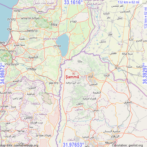
Şammā GPS coordinates[2]
32° 34' 15.672" North, 35° 41' 23.424" East
| Map corner | latitude | longitude |
|---|---|---|
| Upper-left | 33.1616°, | 34.98672° |
| Center: | 32.57102°, | 35.68984° |
| Lower-right: | 31.97653°, | 36.39297° |
| Map W x H: | 131.8×131.8 km | = 81.9×81.9mi |
| max Lat: | 33.31405° ⇑10.1% North |
| Şammā: | 32.57102° |
| min Lat: | ⇓89.9% South 29.40842° |
| min Long | Şammā | max Long |
| 34.97918° | 35.68984° | 38.70342° |
| W 21%⇐ | ⇒79% E |
Elevation
Elevation of Şammā is 320 m = 1050 ft, and this is 365.7 m = 1200 ft below average elevation for this country.
| Max E: |
1440 m = 4724 ft | 91.3% |
| Avg. | 685.7 m = 2250 ft | |
| Şammā | 320 m = 1050 ft | |
Min E: |
-366 m = -1201 ft | 8.7% |
See also: Jordan elevation on elevation.city.
Geographical zone
Şammā is located in North temperate zone (between Tropic of Cancer and the Arctic Circle). Distance of this Northern Tropic circle is 1015.6 km =631.1 mi to South.| Distance of | km | miles | from Şammā |
|---|---|---|---|
| North Pole | 6385.5 | 3967.8 | to North |
| Arctic Circle | 3779.6 | 2348.5 | to North |
| Tropic Cancer | 1015.6 | 631.1 | to South |
| Equator | 3621.6 | 2250.4 | to South |


Nearby cities:
15 places around Şammā: (largest is in red/bold)
• Ash Shūnah ash Shamālīyah
8.9 km =5.5 mi,  307°
307°
• Aţ Ţayyibah
4.1 km =2.5 mi,  140°
140°
• Bayt Yāfā
10.5 km =6.5 mi,  120°
120°
• Bayt Īdis
14.8 km =9.2 mi,  177°
177°
• Dayr Abū Sa‘īd
8.1 km =5 mi, 182°
• Dayr Yūsuf
13.7 km =8.5 mi,  133°
133°
• Kafr Asad
3.7 km =2.3 mi,  35°
35°
• Malkā
12.9 km =8 mi,  25°
25°
• Qumaym
4.2 km =2.6 mi,  88°
88°
• Sammā ar Rawsān
14.8 km =9.2 mi,  59°
59°
• Tibnah
11.3 km =7 mi,  160°
160°
• Umm Qays
9.2 km =5.7 mi,  356°
356°
• Waqqāş
8.6 km =5.3 mi,  247°
247°
• Zaḩar
8.3 km =5.2 mi, 93°
• Ḩātim
11.6 km =7.2 mi,  45°
45°
Sources, notices
• [Note1] Compared only with cities in Jordan existing in our database
• [Src1] Map data: © OpenStreetMap contributors (CC-BY-SA)
• [Src2] Other city data from geonames.org with taken over terms of usage.
• [Src3] Geographical zone / Annual Mean Temperature by Robert A. Rohde @ Wikipedia
