Tibnah geodata
Tibnah (Irbid) is a populated place; located in Jordan in Asia/Amman (GMT+3) time zone. With population of 5,229 people, there are 64 cities with bigger population in this country. Compared to other cities in Jordan, 80.4% of cities are located further ↓South; 68.8% of cities are located further →East and 73.9% of cities have higher elevation than Tibnah. Note1


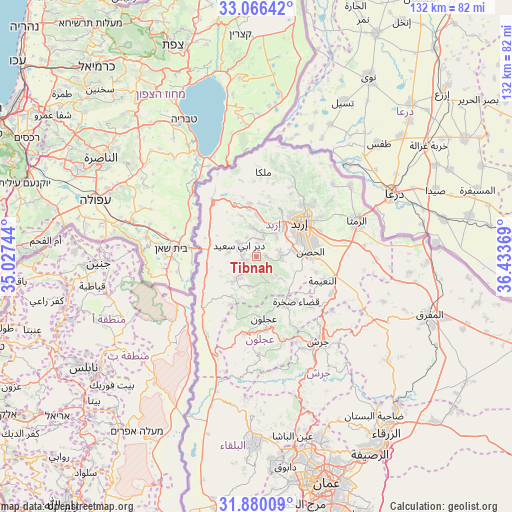
Tibnah GPS coordinates[2]
32° 28' 30.756" North, 35° 43' 50.016" East
| Map corner | latitude | longitude |
|---|---|---|
| Upper-left | 33.06642°, | 35.02744° |
| Center: | 32.47521°, | 35.73056° |
| Lower-right: | 31.88009°, | 36.43369° |
| Map W x H: | 131.9×131.9 km | = 82×82mi |
| max Lat: | 33.31405° ⇑19.6% North |
| Tibnah: | 32.47521° |
| min Lat: | ⇓80.4% South 29.40842° |
| min Long | Tibnah | max Long |
| 34.97918° | 35.73056° | 38.70342° |
| W 31.2%⇐ | ⇒68.8% E |
Elevation
Elevation of Tibnah is 569 m = 1867 ft, and this is 116.7 m = 383 ft below average elevation for this country.
| Max E: |
1440 m = 4724 ft | 73.9% |
| Avg. | 685.7 m = 2250 ft | |
| Tibnah | 569 m = 1867 ft | |
Min E: |
-366 m = -1201 ft | 26.1% |
See also: Jordan elevation on elevation.city.
Geographical zone
Tibnah is located in North temperate zone (between Tropic of Cancer and the Arctic Circle). Distance of this Northern Tropic circle is 1005 km =624.5 mi to South.| Distance of | km | miles | from Tibnah |
|---|---|---|---|
| North Pole | 6396.2 | 3974.4 | to North |
| Arctic Circle | 3790.3 | 2355.2 | to North |
| Tropic Cancer | 1005 | 624.5 | to South |
| Equator | 3610.9 | 2243.7 | to South |


Nearby cities:
15 places around Tibnah: (largest is in red/bold)
• Al Mazār ash Shamālī
6.2 km =3.9 mi,  94°
94°
• Aydūn
12.4 km =7.7 mi,  74°
74°
• Aţ Ţayyibah
7.6 km =4.7 mi,  350°
350°
• Bayt Yāfā
7.4 km =4.6 mi,  44°
44°
• Bayt Īdis
5.2 km =3.2 mi,  216°
216°
• Dayr Abū Sa‘īd
4.8 km =3 mi,  301°
301°
• Dayr Yūsuf
6.3 km =3.9 mi,  77°
77°
• Judita
7.8 km =4.8 mi,  195°
195°
• Kafr Abīl
9 km =5.6 mi, 224°
• Qumaym
10.7 km =6.6 mi,  1°
1°
• Zaḩar
11.1 km =6.9 mi,  23°
23°
• Şammā
11.3 km =7 mi,  340°
340°
• Ţabaqat Faḩl
11.7 km =7.3 mi,  256°
256°
• Ḩalāwah
12 km =7.5 mi,  212°
212°
• ‘Irjān
9 km =5.6 mi,  178°
178°
Sources, notices
• [Note1] Compared only with cities in Jordan existing in our database
• [Src1] Map data: © OpenStreetMap contributors (CC-BY-SA)
• [Src2] Other city data from geonames.org with taken over terms of usage.
• [Src3] Geographical zone / Annual Mean Temperature by Robert A. Rohde @ Wikipedia
