Ash Shūnah ash Shamālīyah geodata
Ash Shūnah ash Shamālīyah (Irbid) is a seat of a second-order administrative division; located in Jordan in Asia/Amman (GMT+3) time zone. In our database, there are 84 cities with bigger population. Compared to other cities in Jordan, 92.8% of cities are located further ↓South; 85.5% of cities are located further →East and 96.4% of cities have higher elevation than Ash Shūnah ash Shamālīyah. Note1
Current local time in Ash Shūnah ash Shamālīyah:
06:04 PM, ThursdayDifference from your time zone: hours


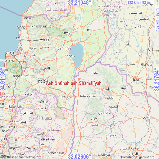
Ash Shūnah ash Shamālīyah GPS coordinates[2]
32° 37' 12.828" North, 35° 36' 52.236" East
| Map corner | latitude | longitude |
|---|---|---|
| Upper-left | 33.21048°, | 34.91139° |
| Center: | 32.62023°, | 35.61451° |
| Lower-right: | 32.02606°, | 36.31764° |
| Map W x H: | 131.7×131.7 km | = 81.8×81.8mi |
| max Lat: | 33.31405° ⇑7.2% North |
| Ash Shūnah ash Shamālīyah: | 32.62023° |
| min Lat: | ⇓92.8% South 29.40842° |
| min Long | Ash Shūnah ash | max Long |
| 34.97918° | 35.61451° | 38.70342° |
| W 14.5%⇐ | ⇒85.5% E |
Elevation
Elevation of Ash Shūnah ash Shamālīyah is -196 m = -643 ft, and this is 881.7 m = 2893 ft below average elevation for this country.
| Max E: |
1440 m = 4724 ft | 96.4% |
| Avg. | 685.7 m = 2250 ft | |
| Ash Shūnah ash Shamālīyah | -196 m = -643 ft | |
Min E: |
-366 m = -1201 ft | 3.6% |
See also: Jordan elevation on elevation.city.
Geographical zone
Ash Shūnah ash Shamālīyah is located in North temperate zone (between Tropic of Cancer and the Arctic Circle). Distance of this Northern Tropic circle is 1021.1 km =634.5 mi to South.| Distance of | km | miles | from Ash Shūnah ash Shamālīyah |
|---|---|---|---|
| North Pole | 6380 | 3964.3 | to North |
| Arctic Circle | 3774.1 | 2345.1 | to North |
| Tropic Cancer | 1021.1 | 634.5 | to South |
| Equator | 3627 | 2253.7 | to South |


Nearby cities:
15 places around Ash Shūnah ash Shamālīyah: (largest is in red/bold)
• Aţ Ţayyibah
12.9 km =8 mi,  131°
131°
• Bayt Yāfā
19.4 km =12.1 mi,  124°
124°
• Dayr Abū Sa‘īd
15.2 km =9.4 mi,  153°
153°
• Kafr Asad
9.5 km =5.9 mi,  105°
105°
• Kafr Sawm
18.9 km =11.7 mi,  67°
67°
• Malkā
14 km =8.7 mi,  63°
63°
• Qumaym
12.5 km =7.8 mi, 115°
• Saḩam al Kaffārāt
17.3 km =10.7 mi, 59°
• Tibnah
19.5 km =12.1 mi, 145°
• Umm Qays
7.5 km =4.7 mi, 60°
• Waqqāş
8.7 km =5.4 mi,  185°
185°
• Zaḩar
16.4 km =10.2 mi, 111°
• Şammā
8.9 km =5.5 mi, 127°
• Ţabaqat Faḩl
18.8 km =11.7 mi,  181°
181°
• Ḩātim
15.5 km =9.6 mi,  79°
79°
Sources, notices
• [Note1] Compared only with cities in Jordan existing in our database
• [Src1] Map data: © OpenStreetMap contributors (CC-BY-SA)
• [Src2] Other city data from geonames.org with taken over terms of usage.
• [Src3] Geographical zone / Annual Mean Temperature by Robert A. Rohde @ Wikipedia
