Amman geodata
Amman is a capital of a political entity; located in Jordan in Asia/Amman (GMT+3) time zone. With population of 1,275,857 people, there are 0 cities with bigger population in this country. Compared to other cities in Jordan, 58.7% of cities are located further ↑North; 74.6% of cities are located further ←West and 52.9% of cities have lower elevation than Amman. Note1


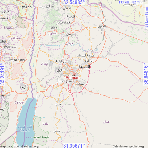
Amman GPS coordinates[2]
31° 57' 18.792" North, 35° 56' 42.108" East
| Map corner | latitude | longitude |
|---|---|---|
| Upper-left | 32.54985°, | 35.24191° |
| Center: | 31.95522°, | 35.94503° |
| Lower-right: | 31.35671°, | 36.64816° |
| Map W x H: | 132.7×132.7 km | = 82.5×82.5mi |
| max Lat: | 33.31405° ⇑58.7% North |
| Amman: | 31.95522° |
| min Lat: | ⇓41.3% South 29.40842° |
| min Long | Amman | max Long |
| 34.97918° | 35.94503° | 38.70342° |
| W 74.6%⇐ | ⇒25.4% E |
Elevation
Elevation of Amman is 757 m = 2484 ft, and this is 71.3 m = 234 ft above average elevation for this country.
| Max E: |
1440 m = 4724 ft | 47.1% |
| Amman | 757 m 2484 ft | |
| Avg. | 685.7 m = 2250 ft | |
Min E: |
-366 m = -1201 ft | 52.9% |
See also: Amman elevation on elevation.city.
Geographical zone
Amman is located in North temperate zone (between Tropic of Cancer and the Arctic Circle). Distance of this Northern Tropic circle is 947.2 km =588.6 mi to South.| Distance of | km | miles | from Amman |
|---|---|---|---|
| North Pole | 6454 | 4010.3 | to North |
| Arctic Circle | 3848.1 | 2391.1 | to North |
| Tropic Cancer | 947.2 | 588.6 | to South |
| Equator | 3553.1 | 2207.8 | to South |


Nearby cities:
15 places around Amman: (largest is in red/bold)
• Al Jubayhah
7.6 km =4.7 mi,  324°
324°
• Al Juwayyidah
7.7 km =4.8 mi,  189°
189°
• Al ‘Abdallī
3.6 km =2.2 mi,  287°
287°
• Ar Ruşayfah
10.8 km =6.7 mi,  50°
50°
• Jāwā
11.4 km =7.1 mi,  182°
182°
• Nā‘ūr
14.5 km =9 mi,  231°
231°
• Rujm ash Shāmī al Gharbī
14.3 km =8.9 mi,  156°
156°
• Russeifa
11.8 km =7.3 mi, 53°
• Saḩāb
11 km =6.8 mi,  149°
149°
• Umm al Basātīn
15.9 km =9.9 mi,  203°
203°
• Umm as Summāq
11.6 km =7.2 mi, 227°
• Wādī as Sīr
12 km =7.5 mi,  269°
269°
• Ḩayy al Bunayyāt
8.7 km =5.4 mi,  220°
220°
• Ḩayy al Quwaysimah
5 km =3.1 mi,  174°
174°
• ‘Ayn al Bāshā
15.6 km =9.7 mi, 316°
Sources, notices
• [Note1] Compared only with cities in Jordan existing in our database
• [Src1] Map data: © OpenStreetMap contributors (CC-BY-SA)
• [Src2] Other city data from geonames.org with taken over terms of usage.
• [Src3] Geographical zone / Annual Mean Temperature by Robert A. Rohde @ Wikipedia
