Bīrayn geodata
Bīrayn (Zarqa) is a seat of a third-order administrative division; located in Jordan in Asia/Amman (GMT+3) time zone. In our database, there are 84 cities with bigger population. Compared to other cities in Jordan, 50.7% of cities are located further ↑North; 76.8% of cities are located further ←West and 52.9% of cities have higher elevation than Bīrayn. Note1


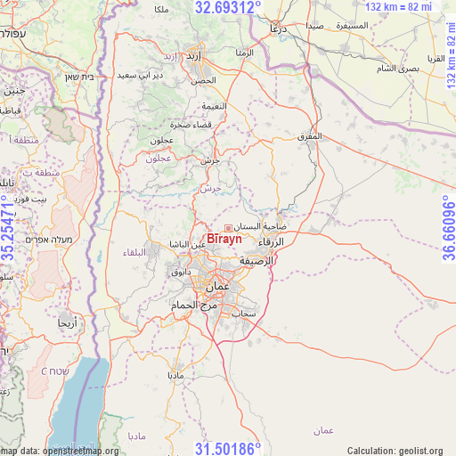
Bīrayn GPS coordinates[2]
32° 5' 57.948" North, 35° 57' 28.188" East
| Map corner | latitude | longitude |
|---|---|---|
| Upper-left | 32.69312°, | 35.25471° |
| Center: | 32.09943°, | 35.95783° |
| Lower-right: | 31.50186°, | 36.66096° |
| Map W x H: | 132.5×132.5 km | = 82.3×82.3mi |
| max Lat: | 33.31405° ⇑50.7% North |
| Bīrayn: | 32.09943° |
| min Lat: | ⇓49.3% South 29.40842° |
| min Long | Bīrayn | max Long |
| 34.97918° | 35.95783° | 38.70342° |
| W 76.8%⇐ | ⇒23.2% E |
Elevation
Elevation of Bīrayn is 701 m = 2300 ft, and this is 15.3 m = 50 ft above average elevation for this country.
| Max E: |
1440 m = 4724 ft | 52.9% |
| Bīrayn | 701 m 2300 ft | |
| Avg. | 685.7 m = 2250 ft | |
Min E: |
-366 m = -1201 ft | 47.1% |
See also: Jordan elevation on elevation.city.
Geographical zone
Bīrayn is located in North temperate zone (between Tropic of Cancer and the Arctic Circle). Distance of this Northern Tropic circle is 963.2 km =598.5 mi to South.| Distance of | km | miles | from Bīrayn |
|---|---|---|---|
| North Pole | 6437.9 | 4000.3 | to North |
| Arctic Circle | 3832.1 | 2381.2 | to North |
| Tropic Cancer | 963.2 | 598.5 | to South |
| Equator | 3569.1 | 2217.7 | to South |


Nearby cities:
15 places around Bīrayn: (largest is in red/bold)
• Al Fuḩayş
19.7 km =12.2 mi,  237°
237°
• Al Hāshimīyah
15.7 km =9.8 mi,  77°
77°
• Al Jubayhah
11.4 km =7.1 mi,  209°
209°
• Al Maşţabah
13.5 km =8.4 mi,  314°
314°
• Al ‘Abdallī
15.7 km =9.8 mi,  197°
197°
• Amman
16.1 km =10 mi,  184°
184°
• Ar Ruşayfah
11.5 km =7.1 mi,  142°
142°
• Bal‘amā
19.6 km =12.2 mi,  38°
38°
• Jarash
20.9 km =13 mi,  344°
344°
• Russeifa
12.3 km =7.6 mi, 137°
• Wādī as Sīr
20.8 km =12.9 mi,  219°
219°
• Zarqa
12.6 km =7.8 mi,  103°
103°
• Ḩayy al Quwaysimah
21 km =13 mi, 182°
• ‘Allān
20.3 km =12.6 mi,  275°
275°
• ‘Ayn al Bāshā
12.8 km =8 mi,  248°
248°
Sources, notices
• [Note1] Compared only with cities in Jordan existing in our database
• [Src1] Map data: © OpenStreetMap contributors (CC-BY-SA)
• [Src2] Other city data from geonames.org with taken over terms of usage.
• [Src3] Geographical zone / Annual Mean Temperature by Robert A. Rohde @ Wikipedia
