‘Ayn al Bāshā geodata
‘Ayn al Bāshā (Balqa) is a seat of a second-order administrative division; located in Jordan in Asia/Amman (GMT+3) time zone. In our database, there are 84 cities with bigger population. Compared to other cities in Jordan, 52.9% of cities are located further ↑North; 57.2% of cities are located further ←West and 59.4% of cities have higher elevation than ‘Ayn al Bāshā. Note1


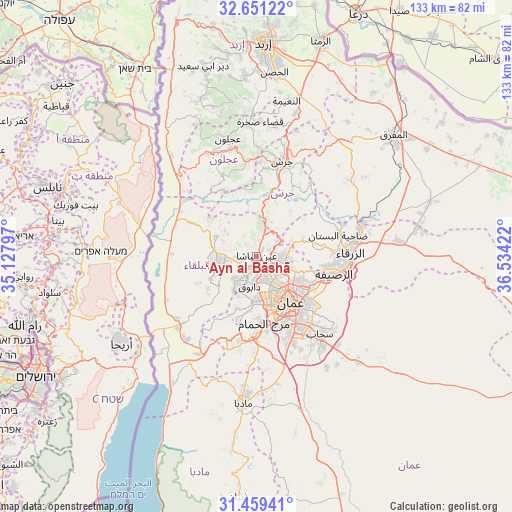
‘Ayn al Bāshā GPS coordinates[2]
32° 3' 26.136" North, 35° 49' 51.924" East
| Map corner | latitude | longitude |
|---|---|---|
| Upper-left | 32.65122°, | 35.12797° |
| Center: | 32.05726°, | 35.83109° |
| Lower-right: | 31.45941°, | 36.53422° |
| Map W x H: | 132.5×132.5 km | = 82.3×82.3mi |
| max Lat: | 33.31405° ⇑52.9% North |
| ‘Ayn al Bāshā: | 32.05726° |
| min Lat: | ⇓47.1% South 29.40842° |
| min Long | ‘Ayn al Bāsh | max Long |
| 34.97918° | 35.83109° | 38.70342° |
| W 57.2%⇐ | ⇒42.8% E |
Elevation
Elevation of ‘Ayn al Bāshā is 663 m = 2175 ft, and this is 22.7 m = 74 ft below average elevation for this country.
| Max E: |
1440 m = 4724 ft | 59.4% |
| Avg. | 685.7 m = 2250 ft | |
| ‘Ayn al Bāshā | 663 m = 2175 ft | |
Min E: |
-366 m = -1201 ft | 40.6% |
See also: Jordan elevation on elevation.city.
Geographical zone
‘Ayn al Bāshā is located in North temperate zone (between Tropic of Cancer and the Arctic Circle). Distance of this Northern Tropic circle is 958.5 km =595.6 mi to South.| Distance of | km | miles | from ‘Ayn al Bāshā |
|---|---|---|---|
| North Pole | 6442.6 | 4003.2 | to North |
| Arctic Circle | 3836.7 | 2384 | to North |
| Tropic Cancer | 958.5 | 595.6 | to South |
| Equator | 3564.4 | 2214.8 | to South |


Nearby cities:
15 places around ‘Ayn al Bāshā: (largest is in red/bold)
• Al Fuḩayş
7.5 km =4.7 mi,  218°
218°
• Al Jubayhah
8.2 km =5.1 mi,  129°
129°
• Al Maşţabah
14.3 km =8.9 mi,  9°
9°
• Al ‘Abdallī
12.6 km =7.8 mi,  144°
144°
• Amman
15.6 km =9.7 mi, 136°
• Ar Ruşayfah
19.5 km =12.1 mi,  103°
103°
• As Salţ
10 km =6.2 mi,  258°
258°
• Aş Şubayḩī
15.6 km =9.7 mi,  310°
310°
• Burmā
18.5 km =11.5 mi,  346°
346°
• Bīrayn
12.8 km =8 mi,  68°
68°
• Umm as Summāq
19.2 km =11.9 mi,  173°
173°
• Wādī as Sīr
11.5 km =7.1 mi,  186°
186°
• Yarqā
15.6 km =9.7 mi,  234°
234°
• Ḩayy al Bunayyāt
18.6 km =11.6 mi,  164°
164°
• ‘Allān
10.7 km =6.6 mi, 309°
Sources, notices
• [Note1] Compared only with cities in Jordan existing in our database
• [Src1] Map data: © OpenStreetMap contributors (CC-BY-SA)
• [Src2] Other city data from geonames.org with taken over terms of usage.
• [Src3] Geographical zone / Annual Mean Temperature by Robert A. Rohde @ Wikipedia
