Zarqa geodata
Zarqa is a seat of a first-order administrative division; located in Jordan in Asia/Amman (GMT+3) time zone. With population of 792,665 people, there is 1 city with bigger population in this country. Compared to other cities in Jordan, 52.2% of cities are located further ↑North; 84.1% of cities are located further ←West and 63% of cities have higher elevation than Zarqa. Note1


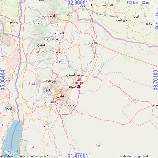
Zarqa GPS coordinates[2]
32° 4' 21.9" North, 36° 5' 16.656" East
| Map corner | latitude | longitude |
|---|---|---|
| Upper-left | 32.66661°, | 35.38484° |
| Center: | 32.07275°, | 36.08796° |
| Lower-right: | 31.47501°, | 36.79109° |
| Map W x H: | 132.5×132.5 km | = 82.3×82.3mi |
| max Lat: | 33.31405° ⇑52.2% North |
| Zarqa: | 32.07275° |
| min Lat: | ⇓47.8% South 29.40842° |
| min Long | Zarqa | max Long |
| 34.97918° | 36.08796° | 38.70342° |
| W 84.1%⇐ | ⇒15.9% E |
Elevation
Elevation of Zarqa is 625 m = 2051 ft, and this is 60.7 m = 199 ft below average elevation for this country.
| Max E: |
1440 m = 4724 ft | 63% |
| Avg. | 685.7 m = 2250 ft | |
| Zarqa | 625 m = 2051 ft | |
Min E: |
-366 m = -1201 ft | 37% |
See also: Zarqa elevation on elevation.city.
Geographical zone
Zarqa is located in North temperate zone (between Tropic of Cancer and the Arctic Circle). Distance of this Northern Tropic circle is 960.2 km =596.6 mi to South.| Distance of | km | miles | from Zarqa |
|---|---|---|---|
| North Pole | 6440.9 | 4002.2 | to North |
| Arctic Circle | 3835 | 2383 | to North |
| Tropic Cancer | 960.2 | 596.6 | to South |
| Equator | 3566.2 | 2215.9 | to South |


Nearby cities:
15 places around Zarqa: (largest is in red/bold)
• Al Hāshimīyah
7 km =4.3 mi,  26°
26°
• Al Jubayhah
19.2 km =11.9 mi,  248°
248°
• Al Khālidīyah
23.5 km =14.6 mi,  59°
59°
• Al Maşţabah
25.1 km =15.6 mi,  299°
299°
• Al ‘Abdallī
20.8 km =12.9 mi,  234°
234°
• Amman
18.8 km =11.7 mi, 225°
• Ar Ruşayfah
8.1 km =5 mi,  220°
220°
• Az̧ Z̧ulayl
18.9 km =11.7 mi,  73°
73°
• Bal‘amā
18.2 km =11.3 mi,  0°
0°
• Bīrayn
12.6 km =7.8 mi,  283°
283°
• Qaşr al Ḩallābāt
23.2 km =14.4 mi,  83°
83°
• Russeifa
7.3 km =4.5 mi,  212°
212°
• Saḩāb
23.8 km =14.8 mi,  199°
199°
• Ḩayy al Quwaysimah
22.3 km =13.9 mi, 215°
• ‘Ayn al Bāshā
24.3 km =15.1 mi,  265°
265°
Sources, notices
• [Note1] Compared only with cities in Jordan existing in our database
• [Src1] Map data: © OpenStreetMap contributors (CC-BY-SA)
• [Src2] Other city data from geonames.org with taken over terms of usage.
• [Src3] Geographical zone / Annual Mean Temperature by Robert A. Rohde @ Wikipedia
