Russeifa geodata
Russeifa (Zarqa) is a populated place; located in Jordan in Asia/Amman (GMT+3) time zone. With population of 268,237 people, there are 3 cities with bigger population in this country. Compared to other cities in Jordan, 54.3% of cities are located further ↑North; 81.9% of cities are located further ←West and 65.2% of cities have higher elevation than Russeifa. Note1


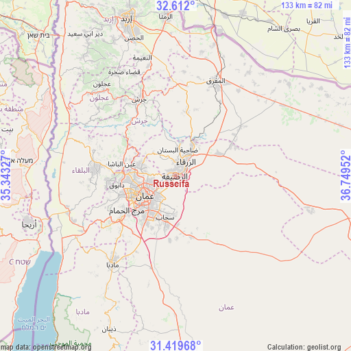
Russeifa GPS coordinates[2]
32° 1' 4.008" North, 36° 2' 47.004" East
| Map corner | latitude | longitude |
|---|---|---|
| Upper-left | 32.612°, | 35.34327° |
| Center: | 32.01778°, | 36.04639° |
| Lower-right: | 31.41968°, | 36.74952° |
| Map W x H: | 132.6×132.6 km | = 82.4×82.4mi |
| max Lat: | 33.31405° ⇑54.3% North |
| Russeifa: | 32.01778° |
| min Lat: | ⇓45.7% South 29.40842° |
| min Long | Russeifa | max Long |
| 34.97918° | 36.04639° | 38.70342° |
| W 81.9%⇐ | ⇒18.1% E |
Elevation
Elevation of Russeifa is 614 m = 2014 ft, and this is 71.7 m = 235 ft below average elevation for this country.
| Max E: |
1440 m = 4724 ft | 65.2% |
| Avg. | 685.7 m = 2250 ft | |
| Russeifa | 614 m = 2014 ft | |
Min E: |
-366 m = -1201 ft | 34.8% |
See also: Russeifa elevation on elevation.city.
Geographical zone
Russeifa is located in North temperate zone (between Tropic of Cancer and the Arctic Circle). Distance of this Northern Tropic circle is 954.1 km =592.9 mi to South.| Distance of | km | miles | from Russeifa |
|---|---|---|---|
| North Pole | 6447 | 4006 | to North |
| Arctic Circle | 3841.1 | 2386.7 | to North |
| Tropic Cancer | 954.1 | 592.9 | to South |
| Equator | 3560 | 2212.1 | to South |


Nearby cities:
15 places around Russeifa: (largest is in red/bold)
• Al Hāshimīyah
14.2 km =8.8 mi,  29°
29°
• Al Jubayhah
14 km =8.7 mi,  266°
266°
• Al Juwayyidah
18.1 km =11.2 mi,  216°
216°
• Al ‘Abdallī
14.3 km =8.9 mi,  245°
245°
• Amman
11.8 km =7.3 mi,  233°
233°
• Ar Ruşayfah
1.3 km =0.8 mi, 267°
• Bīrayn
12.3 km =7.6 mi,  317°
317°
• Jāwā
21 km =13 mi,  208°
208°
• Rujm ash Shāmī al Gharbī
20.5 km =12.7 mi,  191°
191°
• Saḩāb
16.9 km =10.5 mi, 193°
• Wādī as Sīr
22.6 km =14 mi, 251°
• Zarqa
7.3 km =4.5 mi, 32°
• Ḩayy al Bunayyāt
20.4 km =12.7 mi, 228°
• Ḩayy al Quwaysimah
15 km =9.3 mi, 217°
• ‘Ayn al Bāshā
20.8 km =12.9 mi,  282°
282°
Sources, notices
• [Note1] Compared only with cities in Jordan existing in our database
• [Src1] Map data: © OpenStreetMap contributors (CC-BY-SA)
• [Src2] Other city data from geonames.org with taken over terms of usage.
• [Src3] Geographical zone / Annual Mean Temperature by Robert A. Rohde @ Wikipedia
