Yamakita geodata
Yamakita (Kanagawa) is a seat of a third-order administrative division; located in Japan in Asia/Tokyo (GMT+9) time zone. In our database, there are 767 cities with bigger population. Compared to other cities in Japan, 50.3% of cities are located further ↑North; 61.7% of cities are located further ←West and 82.4% of cities have lower elevation than Yamakita. Note1


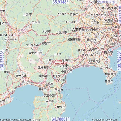
Yamakita GPS coordinates[2]
35° 21' 48.384" North, 139° 4' 47.1" East
| Map corner | latitude | longitude |
|---|---|---|
| Upper-left | 35.9348°, | 138.37663° |
| Center: | 35.36344°, | 139.07975° |
| Lower-right: | 34.78801°, | 139.78288° |
| Map W x H: | 127.5×127.5 km | = 79.2×79.2mi |
| max Lat: | 45.40944° ⇑50.3% North |
| Yamakita: | 35.36344° |
| min Lat: | ⇓49.7% South 24.34478° |
| min Long | Yamakita | max Long |
| 123° | 139.07975° | 145.575° |
| W 61.7%⇐ | ⇒38.3% E |
Elevation
Elevation of Yamakita is 144 m = 472 ft, and this is 59.4 m = 195 ft above average elevation for this country.
| Max E: |
1086 m = 3563 ft | 17.6% |
| Yamakita | 144 m 472 ft | |
| Avg. | 84.6 m = 278 ft | |
Min E: |
-2 m = -7 ft | 82.4% |
See also: Japan elevation on elevation.city.
Geographical zone
Yamakita is located in North temperate zone (between Tropic of Cancer and the Arctic Circle). Distance of this Northern Tropic circle is 1326.1 km =824 mi to South.| Distance of | km | miles | from Yamakita |
|---|---|---|---|
| North Pole | 6075 | 3774.8 | to North |
| Arctic Circle | 3469.1 | 2155.6 | to North |
| Tropic Cancer | 1326.1 | 824 | to South |
| Equator | 3932 | 2443.2 | to South |


Nearby cities:
15 places around Yamakita: (largest is in red/bold)
• Atsugi
27.7 km =17.2 mi,  71°
71°
• Fujiyoshida
27.1 km =16.8 mi,  288°
288°
• Gotenba
13.3 km =8.3 mi,  248°
248°
• Hadano
13.1 km =8.1 mi,  86°
86°
• Hakone
19.9 km =12.4 mi,  194°
194°
• Hiratsuka
23.7 km =14.7 mi,  99°
99°
• Isehara
21.3 km =13.2 mi,  79°
79°
• Minamiashigara
5.6 km =3.5 mi,  151°
151°
• Ninomiya
17.4 km =10.8 mi,  113°
113°
• Odawara
14 km =8.7 mi, 148°
• Sagamihara
27 km =16.8 mi,  32°
32°
• Susono
26.3 km =16.3 mi,  216°
216°
• Tsuru
25.6 km =15.9 mi,  322°
322°
• Yugawara
23.8 km =14.8 mi,  182°
182°
• Ōiso
22.1 km =13.7 mi, 103°
Sources, notices
• [Note1] Compared only with cities in Japan existing in our database
• [Src1] Map data: © OpenStreetMap contributors (CC-BY-SA)
• [Src2] Other city data from geonames.org with taken over terms of usage.
• [Src3] Geographical zone / Annual Mean Temperature by Robert A. Rohde @ Wikipedia
